
Carte topographique Sattelnock - Corno del Passo
Carte interactive
Cliquez sur la carte pour afficher l’altitude.
À propos de cette carte
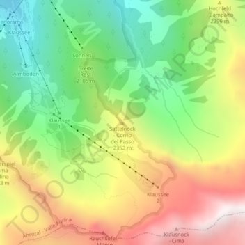
Nom : Carte topographique Sattelnock - Corno del Passo, altitude, relief.
Altitude moyenne : 2 149 m
Altitude minimum : 1 530 m
Altitude maximum : 2 912 m
Autres cartes topographiques
Cliquez sur une carte pour visualiser sa topographie, son altitude et son relief.
Steinhaus - Cadipietra
Italy > Trentino-Alto Adige/Südtirol > South Tyrol > Ahrntal - Valle Aurina
Steinhaus - Cadipietra, Ahrntal - Valle Aurina, Pustertal - Val Pusteria, South Tyrol, Trentino-Alto Adige/Südtirol, Italy
Altitude moyenne : 1 491 m