
Carte topographique Döbrastöcken
Carte interactive
Cliquez sur la carte pour afficher l’altitude.
À propos de cette carte
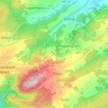
Nom : Carte topographique Döbrastöcken, altitude, relief.
Lieu : Döbrastöcken, Naila, Landkreis Hof, Bayern, 95131, Deutschland (50.26933 11.63788 50.30933 11.67788)
Altitude moyenne : 646 m
Altitude minimum : 533 m
Altitude maximum : 794 m
Autres cartes topographiques
Cliquez sur une carte pour visualiser sa topographie, son altitude et son relief.
Schneckengrün
Deutschland > Bayern > Landkreis Hof > Naila
Schneckengrün, Naila, Landkreis Hof, Bayern, 95119, Deutschland
Altitude moyenne : 574 m
Lippertsgrün
Deutschland > Bayern > Landkreis Hof > Naila > Lippertsgrün
Lippertsgrün, Naila, Landkreis Hof, Bayern, 95119, Deutschland
Altitude moyenne : 633 m
Linden
Deutschland > Bayern > Landkreis Hof > Naila > Linden
Linden, Naila, Landkreis Hof, Bayern, 95119, Deutschland
Altitude moyenne : 557 m
Marlesreuth
Deutschland > Bayern > Landkreis Hof > Naila
Marlesreuth, Naila, Landkreis Hof, Bayern, 95119, Deutschland
Altitude moyenne : 595 m