
Faire un don
Équipez-vous pour votre prochaine aventure :
En tant que Partenaire Amazon, ce site perçoit une commission sur les achats éligibles sans surcoût pour vous.
Carte topographique Greenbrae
Cliquez sur la carte pour afficher l’altitude.
Faire un don
Équipez-vous pour votre prochaine aventure :
En tant que Partenaire Amazon, ce site perçoit une commission sur les achats éligibles sans surcoût pour vous.
À propos de cette carte
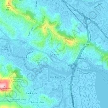
Nom : Carte topographique Greenbrae, altitude, relief.
Lieu : Greenbrae, Marin County, California, 94925, United States (37.92854 -122.54470 37.96854 -122.50470)
Altitude moyenne : 26 m
Altitude minimum : -3 m
Altitude maximum : 224 m
Faire un don
Équipez-vous pour votre prochaine aventure :
En tant que Partenaire Amazon, ce site perçoit une commission sur les achats éligibles sans surcoût pour vous.
Autres cartes topographiques
Cliquez sur une carte pour visualiser sa topographie, son altitude et son relief.
Corte Madera
United States > California > Marin County
Corte Madera (/ˈkɔːrtə məˈdɛrə/; Spanish for "Chop Wood") is an incorporated town in Marin County, California. Corte Madera is located 3.25 miles (5.2 km) south of San Rafael, at an elevation of 39 feet (12 m). The population was 10,222 at the 2020 census. The town was named after the Spanish…
Altitude moyenne : 52 m
Cascade Canyon Open Space Preserve
United States > California > Marin County > Fairfax > Manor
Altitude moyenne : 191 m
Faire un don
Équipez-vous pour votre prochaine aventure :
En tant que Partenaire Amazon, ce site perçoit une commission sur les achats éligibles sans surcoût pour vous.
Tamalpais-Homestead Valley
United States > California > Marin County > Mill Valley
Altitude moyenne : 92 m
San Geronimo
United States > California > Marin County
San Geronimo (Spanish: San Gerónimo, meaning "St. Jerome") is a census-designated place (CDP) located in the San Geronimo Valley in Marin County, California in the United States. San Geronimo is located with Lagunitas-Forest Knolls to its west, Woodacre to its east, and 8 miles (13 km) southwest of downtown…
Altitude moyenne : 234 m