
Carte topographique Saint Barthélemy
Carte interactive
Cliquez sur la carte pour afficher l’altitude.
À propos de cette carte
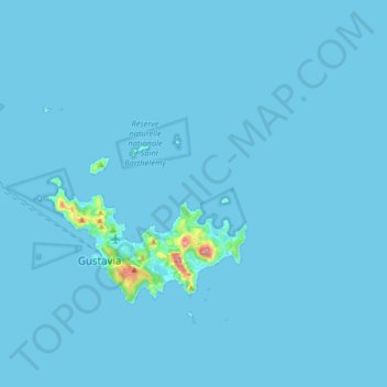
Nom : Carte topographique Saint Barthélemy, altitude, relief.
Lieu : Saint Barthélemy, 97133, France (17.87082 -62.95112 17.97410 -62.78903)
Altitude moyenne : 4 m
Altitude minimum : 0 m
Altitude maximum : 246 m
Morne de Vitet, 286 metres (938 feet) in height, is the highest peak on the island. Hills and valleys of varying topography cover the rest of the island. Notable are Morne Rouge, Morne Criquet, Morne de Grand Fond, Morne de Dépoudré and Morne Lurin. The largest bodies of water on the island are Étang de Saint-Jean, Grande Saline, Grand Étang, and Petit Étang.