Carte topographique Saint-Georges
Carte interactive
Cliquez sur la carte pour afficher l’altitude.
À propos de cette carte
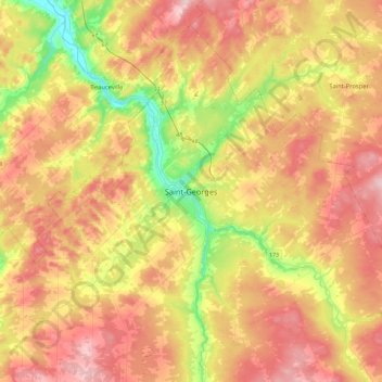
Autres cartes topographiques
Cliquez sur une carte pour visualiser sa topographie, son altitude et son relief.
![Carte topographique Saint-Théophile, altitude, relief](/pub/maps/relation/wts8/lfgf51/icon.jpg)
Saint-Théophile
Canada > Québec > Beauce-Sartigan
Saint-Théophile, Beauce-Sartigan, Chaudière-Appalaches, Québec, G0M 2A0, Canada
Altitude moyenne : 413 m
![Carte topographique Saint-Simon-les-Mines, altitude, relief](/pub/maps/relation/lj51/1v3vnx/icon.jpg)
Saint-Simon-les-Mines
Canada > Québec > Beauce-Sartigan
Saint-Simon-les-Mines, Beauce-Sartigan, Chaudière-Appalaches, Québec, Canada
Altitude moyenne : 285 m
![Carte topographique Lac Wilson, altitude, relief](/pub/maps/way/kwkl/svdhhz4/icon.jpg)
Lac Wilson
Canada > Québec > Beauce-Sartigan > Saint-Théophile
Lac Wilson, Saint-Théophile, Beauce-Sartigan, Chaudière-Appalaches, Québec, Canada
Altitude moyenne : 510 m
![Carte topographique Notre-Dame-des-Pins, altitude, relief](/pub/maps/relation/9114/4m7m3q/icon.jpg)
Notre-Dame-des-Pins
Canada > Québec > Beauce-Sartigan
Notre-Dame-des-Pins, Beauce-Sartigan, Chaudière-Appalaches, Québec, Canada
Altitude moyenne : 242 m
![Carte topographique Beauce, altitude, relief](/pub/maps/relation/wfb3/5w9rgp/icon.jpg)
Beauce
Canada > Québec > Beauce-Sartigan
Beauce, Beauce-Sartigan, Chaudière-Appalaches, Québec, Canada
Altitude moyenne : 377 m
![Carte topographique Saint-Gédéon-de-Beauce, altitude, relief](/pub/maps/relation/6rmt/k9z91h/icon.jpg)
Saint-Gédéon-de-Beauce
Canada > Québec > Beauce-Sartigan
Saint-Gédéon-de-Beauce, Beauce-Sartigan, Chaudière-Appalaches, Québec, G0M 1T0, Canada
Altitude moyenne : 374 m
![Carte topographique Saint-Honoré-de-Shenley, altitude, relief](/pub/maps/relation/gpf3/9xcx14/icon.jpg)
Saint-Honoré-de-Shenley
Canada > Québec > Beauce-Sartigan
Saint-Honoré-de-Shenley, Beauce-Sartigan, Chaudière-Appalaches, Québec, G0M 1V0, Canada
Altitude moyenne : 377 m
![Carte topographique Saint-Éphrem-de-Beauce, altitude, relief](/pub/maps/relation/rl5k/k9z9nh/icon.jpg)
Saint-Éphrem-de-Beauce
Canada > Québec > Beauce-Sartigan
Saint-Éphrem-de-Beauce, Beauce-Sartigan, Chaudière-Appalaches, Québec, G0M 1R0, Canada
Altitude moyenne : 315 m
![Carte topographique Saint-Évariste, altitude, relief](/pub/maps/node/9r3l/3h2q71s8/icon.jpg)
Saint-Évariste
Canada > Québec > Beauce-Sartigan > La Guadeloupe
Saint-Évariste, La Guadeloupe, Beauce-Sartigan, Chaudière-Appalaches, Québec, G0M 1G0, Canada
Altitude moyenne : 324 m
![Carte topographique Saint-René, altitude, relief](/pub/maps/relation/5h3l/zchct6/icon.jpg)
Saint-René
Canada > Québec > Beauce-Sartigan
Saint-René, Beauce-Sartigan, Chaudière-Appalaches, Québec, Canada
Altitude moyenne : 320 m
![Carte topographique Saint-Benoît-Labre, altitude, relief](/pub/maps/relation/35rr/jqtqtf/icon.jpg)
Saint-Benoît-Labre
Canada > Québec > Beauce-Sartigan
Saint-Benoît-Labre, Beauce-Sartigan, Chaudière-Appalaches, Québec, Canada
Altitude moyenne : 317 m
![Carte topographique La Guadeloupe, altitude, relief](/pub/maps/relation/cs57/5jnj3l/icon.jpg)
La Guadeloupe
Canada > Québec > Beauce-Sartigan
La Guadeloupe, Beauce-Sartigan, Chaudière-Appalaches, Québec, G0M 1G0, Canada
Altitude moyenne : 329 m
![Carte topographique Lac des Cygnes, altitude, relief](/pub/maps/way/319m/31fnx1h/icon.jpg)
Lac des Cygnes
Canada > Québec > Beauce-Sartigan > Saint-Théophile
Lac des Cygnes, Saint-Théophile, Beauce-Sartigan, Chaudière-Appalaches, Québec, Canada
Altitude moyenne : 529 m
![Carte topographique Lac à France, altitude, relief](/pub/maps/way/3cz4/1b422cz/icon.jpg)
Lac à France
Canada > Québec > Beauce-Sartigan > Saint-Côme–Linière
Lac à France, Saint-Côme–Linière, Beauce-Sartigan, Chaudière-Appalaches, Québec, Canada
Altitude moyenne : 389 m
![Carte topographique Saint-Côme–Linière, altitude, relief](/pub/maps/relation/k2nh/67j7gt/icon.jpg)
Saint-Côme–Linière
Canada > Québec > Beauce-Sartigan
Saint-Côme–Linière, Beauce-Sartigan, Chaudière-Appalaches, Québec, G0M 1J0, Canada
Altitude moyenne : 334 m
![Carte topographique Lac-Poulin, altitude, relief](/pub/maps/relation/7rtp/9xcxz4/icon.jpg)
Lac-Poulin
Canada > Québec > Beauce-Sartigan
Lac-Poulin, Beauce-Sartigan, Chaudière-Appalaches, Québec, Canada
Altitude moyenne : 338 m
![Carte topographique Saint-Évariste-de-Forsyth, altitude, relief](/pub/maps/relation/sjm2/7kqktp/icon.jpg)
Saint-Évariste-de-Forsyth
Canada > Québec > Beauce-Sartigan
Saint-Évariste-de-Forsyth, Beauce-Sartigan, Chaudière-Appalaches, Québec, G0M 1S0, Canada
Altitude moyenne : 370 m
![Carte topographique Saint-Georges, altitude, relief](/pub/maps/relation/bp4s/7kqkgp/icon.jpg)
Saint-Georges
Canada > Québec > Beauce-Sartigan
Saint-Georges, Beauce-Sartigan, Chaudière-Appalaches, Québec, Canada
Altitude moyenne : 296 m