
Carte topographique Pfaffschwende
Carte interactive
Cliquez sur la carte pour afficher l’altitude.
À propos de cette carte
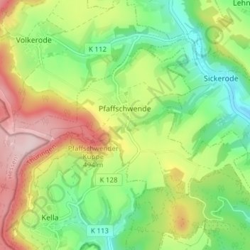
Nom : Carte topographique Pfaffschwende, altitude, relief.
Altitude moyenne : 351 m
Altitude minimum : 227 m
Altitude maximum : 530 m
Autres cartes topographiques
Cliquez sur une carte pour visualiser sa topographie, son altitude et son relief.
Haynrode
Germany > Thuringia > Landkreis Eichsfeld
Haynrode, Eichsfeld-Wipperaue, Landkreis Eichsfeld, Thuringia, Germany
Altitude moyenne : 381 m
Sonnenstein
Germany > Thuringia > Landkreis Eichsfeld
Sonnenstein, Landkreis Eichsfeld, Thuringia, Germany
Altitude moyenne : 295 m