
Carte topographique Stubaier Alpen
Carte interactive
Cliquez sur la carte pour afficher l’altitude.
À propos de cette carte
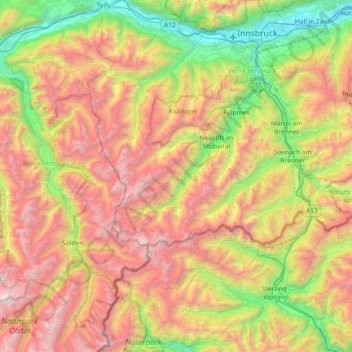
Nom : Carte topographique Stubaier Alpen, altitude, relief.
Lieu : Stubaier Alpen, Tirol, Österreich (46.81071 10.83811 47.31093 11.50503)
Altitude moyenne : 1 892 m
Altitude minimum : 549 m
Altitude maximum : 3 723 m
In den Stubaier Alpen gibt es knapp 500 benannte und mit Höhenkote versehene Gipfel. Zu den bekannteren gehören (geordnet nach der Höhe):
Autres cartes topographiques
Cliquez sur une carte pour visualiser sa topographie, son altitude et son relief.
Neder
Österreich > Tirol > Bezirk Innsbruck-Land > Neustift im Stubaital
Neder, Neustift im Stubaital, Bezirk Innsbruck-Land, Tirol, 6167, Österreich
Altitude moyenne : 1 333 m
Innsbruck
Österreich > Tirol > Innsbruck
Innsbruck, Statutarstadt Innsbruck, Tirol, Österreich
Altitude moyenne : 611 m
Zweitausender
Österreich > Tirol > Bezirk Kitzbühel > Jochberg
Zweitausender, Jochberg, Bezirk Kitzbühel, Tirol, Österreich
Altitude moyenne : 1 784 m
6108
Österreich > Tirol > Bezirk Innsbruck-Land > Scharnitz
6108, Scharnitz, Bezirk Innsbruck-Land, Tirol, Österreich
Altitude moyenne : 1 681 m
6071
Österreich > Tirol > Bezirk Innsbruck-Land > Aldrans
6071, Aldrans, Bezirk Innsbruck-Land, Tirol, Österreich
Altitude moyenne : 1 272 m
Brixentaler Ache, Brixenbach
Österreich > Tirol > Bezirk Kitzbühel > Itter
Brixentaler Ache, Brixenbach, Riesberg, Itter, Bezirk Kitzbühel, Tirol, 6305, Österreich
Altitude moyenne : 826 m
Niederwängle
Österreich > Tirol > Bezirk Reutte > Winkl
Niederwängle, Winkl, Wängle, Bezirk Reutte, Tirol, 6610, Österreich
Altitude moyenne : 1 046 m
6322
Österreich > Tirol > Kirchbichl > Oberndorf
6322, Oberndorf, Kirchbichl, Bezirk Kufstein, Tirol, Österreich
Altitude moyenne : 532 m
6145
Österreich > Tirol > Bezirk Innsbruck-Land > Navis
6145, Navis, Bezirk Innsbruck-Land, Tirol, Österreich
Altitude moyenne : 1 651 m
Pfaffenbichl
Österreich > Tirol > Bezirk Schwaz > Weerberg
Pfaffenbichl, Weerberg, Bezirk Schwaz, Tirol, Österreich
Altitude moyenne : 2 086 m
Spießnägel
Österreich > Tirol > Bezirk Kitzbühel > Kirchberg in Tirol
Spießnägel, Kirchberg in Tirol, Bezirk Kitzbühel, Tirol, Österreich
Altitude moyenne : 1 468 m
Sölden
Österreich > Tirol > Bezirk Imst
Sölden, Bezirk Imst, Tirol, Österreich
Altitude moyenne : 2 483 m
Absam
Österreich > Tirol > Bezirk Innsbruck-Land
Absam, Bezirk Innsbruck-Land, Tirol, 6067, Österreich
Altitude moyenne : 1 363 m
21a
Österreich > Tirol > Bezirk Schwaz > Eben am Achensee
21a, Garberlalm, Eben am Achensee, Bezirk Schwaz, Tirol, 6215, Österreich
Altitude moyenne : 1 269 m
Plansee
Österreich > Tirol > Bezirk Reutte > Breitenwang
Plansee, Breitenwang, Bezirk Reutte, Tirol, Österreich
Altitude moyenne : 1 295 m
Gemeinde Weerberg
Österreich > Tirol > Bezirk Schwaz
Gemeinde Weerberg, Bezirk Schwaz, Tirol, 6133, Österreich
Altitude moyenne : 1 726 m
Going
Österreich > Tirol > Bezirk Kitzbühel > Going am Wilden Kaiser
Going, Going am Wilden Kaiser, Bezirk Kitzbühel, Tirol, 6353, Österreich
Altitude moyenne : 892 m
Rum
Österreich > Tirol > Bezirk Innsbruck-Land
Rum, Bezirk Innsbruck-Land, Tirol, 6063, Österreich
Altitude moyenne : 908 m
Matrei in Osttirol
Österreich > Tirol > Matrei in Osttirol
Matrei in Osttirol, Bezirk Lienz, Tirol, 9971, Österreich
Altitude moyenne : 1 618 m
Tannheimer Tal
Österreich > Tirol > Bezirk Reutte > Gemeinde Grän
Tannheimer Tal, Gemeinde Grän, Bezirk Reutte, Tirol, 6671, Österreich
Altitude moyenne : 1 433 m
Arzl im Pitztal
Österreich > Tirol > Bezirk Imst
Arzl im Pitztal, Bezirk Imst, Tirol, Österreich
Altitude moyenne : 1 672 m
Vergötschen
Österreich > Tirol > Bezirk Landeck
Vergötschen, Kaunertal, Bezirk Landeck, Tirol, 6524, Österreich
Altitude moyenne : 1 843 m
Debanttal
Österreich > Tirol > Bezirk Lienz > Nußdorf-Debant
Debanttal, Nußdorf-Debant, Bezirk Lienz, Tirol, Österreich
Altitude moyenne : 1 741 m
Innerwald
Österreich > Tirol > Bezirk Imst > Sankt Leonhard im Pitztal
Innerwald, Sankt Leonhard im Pitztal, Bezirk Imst, Tirol, 6481, Österreich
Altitude moyenne : 1 909 m
Schlitters
Österreich > Tirol > Bezirk Schwaz
Schlitters, Bezirk Schwaz, Tirol, 6262, Österreich
Altitude moyenne : 814 m
Winkl
Österreich > Tirol > Bezirk Landeck > Galtür
Winkl, Galtür, Bezirk Landeck, Tirol, 6563, Österreich
Altitude moyenne : 2 001 m
Dornau
Österreich > Tirol > Bezirk Schwaz > Finkenberg
Dornau, Finkenberg, Bezirk Schwaz, Tirol, 6292, Österreich
Altitude moyenne : 1 204 m
Wittberg
Österreich > Tirol > Kramsach
Wittberg, Kramsach, Bezirk Kufstein, Tirol, 6233, Österreich
Altitude moyenne : 668 m
Pfafflar
Österreich > Tirol > Bezirk Reutte
Pfafflar, Bezirk Reutte, Tirol, 6647, Österreich
Altitude moyenne : 1 814 m
Aschau
Österreich > Tirol > Bezirk Kitzbühel
Aschau, Kirchberg in Tirol, Bezirk Kitzbühel, Tirol, Österreich
Altitude moyenne : 1 314 m
Oberpettnau
Österreich > Tirol > Bezirk Innsbruck-Land > Pettnau
Oberpettnau, Pettnau, Bezirk Innsbruck-Land, Tirol, 6403, Österreich
Altitude moyenne : 847 m
Tristach
Österreich > Tirol > Bezirk Lienz
Tristach, Bezirk Lienz, Tirol, 9907, Österreich
Altitude moyenne : 1 415 m
Ladis
Österreich > Tirol > Bezirk Landeck
Ladis, Bezirk Landeck, Tirol, 6532, Österreich
Altitude moyenne : 1 337 m
Flirsch
Österreich > Tirol > Bezirk Landeck
Flirsch, Bezirk Landeck, Tirol, 6572, Österreich
Altitude moyenne : 1 980 m
Gemeinde Kirchbichl
Gemeinde Kirchbichl, Bezirk Kufstein, Tirol, Österreich
Altitude moyenne : 612 m
Rammstein
Österreich > Tirol > Bezirk Imst > Stadt Imst
Rammstein, Stadt Imst, Bezirk Imst, Tirol, 6460, Österreich
Altitude moyenne : 2 248 m
Kufstein
Österreich > Tirol > Kufstein
Kufstein, Bezirk Kufstein, Tirol, 6330, Österreich
Altitude moyenne : 725 m
Lüsens
Österreich > Tirol > Bezirk Innsbruck-Land > Gemeinde Sankt Sigmund im Sellrain
Lüsens, Gemeinde Sankt Sigmund im Sellrain, Bezirk Innsbruck-Land, Tirol, Österreich
Altitude moyenne : 2 169 m
Stubaital
Österreich > Tirol > Bezirk Innsbruck-Land > Marktgemeinde Fulpmes
Stubaital, Marktgemeinde Fulpmes, Bezirk Innsbruck-Land, Tirol, 6167, Österreich
Altitude moyenne : 1 590 m
Gemeinde Schönwies
Österreich > Tirol > Bezirk Landeck
Gemeinde Schönwies, Bezirk Landeck, Tirol, 6491, Österreich
Altitude moyenne : 1 614 m
Gemeinde Buch in Tirol
Österreich > Tirol > Bezirk Schwaz
Gemeinde Buch in Tirol, Bezirk Schwaz, Tirol, 6220, Österreich
Altitude moyenne : 913 m
Alpbach
Österreich > Tirol > Gemeinde Alpbach
Alpbach, Gemeinde Alpbach, Bezirk Kufstein, Tirol, 6236, Österreich
Altitude moyenne : 1 222 m
Alpeiner Knotespitze
Österreich > Tirol > Bezirk Innsbruck-Land > Gemeinde Neustift im Stubaital
Alpeiner Knotespitze, Gemeinde Neustift im Stubaital, Bezirk Innsbruck-Land, Tirol, Österreich
Altitude moyenne : 2 791 m
Kirchdorf
Österreich > Tirol > Bezirk Kitzbühel > Gemeinde Kirchdorf in Tirol
Kirchdorf, Gemeinde Kirchdorf in Tirol, Bezirk Kitzbühel, Tirol, 6382, Österreich
Altitude moyenne : 1 009 m
Panzendorf
Österreich > Tirol > Bezirk Lienz
Panzendorf, Gemeinde Heinfels, Bezirk Lienz, Tirol, 9919, Österreich
Altitude moyenne : 1 345 m
Wildes Mannle
Österreich > Tirol > Bezirk Imst > Gemeinde Sölden
Wildes Mannle, Gemeinde Sölden, Bezirk Imst, Tirol, 6458, Österreich
Altitude moyenne : 2 778 m
Tarrenz
Österreich > Tirol > Bezirk Imst
Tarrenz, Bezirk Imst, Tirol, 6464, Österreich
Altitude moyenne : 1 570 m
Mösl
Österreich > Tirol > Bezirk Schwaz > Gemeinde Hippach
Mösl, Gemeinde Hippach, Bezirk Schwaz, Tirol, 6283, Österreich
Altitude moyenne : 1 655 m