
Faire un don
Équipez-vous pour votre prochaine aventure :
En tant que Partenaire Amazon, ce site perçoit une commission sur les achats éligibles sans surcoût pour vous.
Carte topographique Netzen
Cliquez sur la carte pour afficher l’altitude.
Faire un don
Équipez-vous pour votre prochaine aventure :
En tant que Partenaire Amazon, ce site perçoit une commission sur les achats éligibles sans surcoût pour vous.
À propos de cette carte
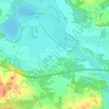
Nom : Carte topographique Netzen, altitude, relief.
Altitude moyenne : 38 m
Altitude minimum : 26 m
Altitude maximum : 72 m
Faire un don
Équipez-vous pour votre prochaine aventure :
En tant que Partenaire Amazon, ce site perçoit une commission sur les achats éligibles sans surcoût pour vous.
Autres cartes topographiques
Cliquez sur une carte pour visualiser sa topographie, son altitude et son relief.
Beetzsee
Deutschland > Brandenburg > Potsdam-Mittelmark
Beetzsee befindet sich etwa 40 Kilometer westlich der Bundeshauptstadt Berlin und im westlichen Bereich der Metropolregion Berlin/Brandenburg. Das Beetzseeufer hat je nach Wasserstand eine Höhe von durchschnittlich 28 bis 29 Meter über Normalnull. Der höchstgelegene Punkt Beetzsees ist der 89,3 Meter hohe…
Altitude moyenne : 33 m
Phöben
Deutschland > Brandenburg > Potsdam-Mittelmark > Werder (Havel)
Bliesendorf mit Resau | Derwitz | Glindow mit Elisabethhöhe | Kemnitz mit Kolonie Zern | Petzow mit Löcknitz und Riegelberg | Phöben | Plötzin mit Neu Plötzin und Plessow | Töplitz mit Alt Töplitz, Eichholz, Göttin, Leest und Neu Töplitz
Altitude moyenne : 35 m
Faire un don
Équipez-vous pour votre prochaine aventure :
En tant que Partenaire Amazon, ce site perçoit une commission sur les achats éligibles sans surcoût pour vous.
Faire un don
Équipez-vous pour votre prochaine aventure :
En tant que Partenaire Amazon, ce site perçoit une commission sur les achats éligibles sans surcoût pour vous.
Faire un don
Équipez-vous pour votre prochaine aventure :
En tant que Partenaire Amazon, ce site perçoit une commission sur les achats éligibles sans surcoût pour vous.
Schloss Wiesenburg
Deutschland > Brandenburg > Potsdam-Mittelmark > Wiesenburg/Mark
Altitude moyenne : 167 m
Kleiner Zernsee
Deutschland > Brandenburg > Potsdam-Mittelmark > Werder (Havel)
Altitude moyenne : 36 m
Faire un don
Équipez-vous pour votre prochaine aventure :
En tant que Partenaire Amazon, ce site perçoit une commission sur les achats éligibles sans surcoût pour vous.
Großer Seddiner See
Deutschland > Brandenburg > Potsdam-Mittelmark > Neuseddin
Der Temperaturverlauf entspricht ungefähr dem bundesdeutschen Durchschnitt. Die jahreszeitlichen Temperaturschwankungen sind mit 18,5 °C geringer als im üblichen kontinentalen Klima, aber höher als im ausgeglicheneren Seeklima der Küstenregionen. Die Jahresmitteltemperatur beträgt rund 9,0 °C. Der…
Altitude moyenne : 47 m
Rädel
Deutschland > Brandenburg > Potsdam-Mittelmark
Der Dorfname Rädel findet sich erstmals 1775 in der Topographie der Mark Brandenburg von Anton Friedrich Büsching. Im Kirchenbuch von Rädel wurde noch bis 1781 die Schreibweise „Redel“ für den Dorfnamen benutzt. Zwischen 1776 und 1778 wurde von Friedrich II. in der Nähe von Rädel eine…
Altitude moyenne : 52 m
Faire un don
Équipez-vous pour votre prochaine aventure :
En tant que Partenaire Amazon, ce site perçoit une commission sur les achats éligibles sans surcoût pour vous.
Rietz Ausbau
Deutschland > Brandenburg > Potsdam-Mittelmark > Treuenbrietzen > Rietz
Altitude moyenne : 78 m
Ruine Lebenswarte
Deutschland > Brandenburg > Potsdam-Mittelmark > Rosenau > Warchau
Altitude moyenne : 45 m
Faire un don
Équipez-vous pour votre prochaine aventure :
En tant que Partenaire Amazon, ce site perçoit une commission sur les achats éligibles sans surcoût pour vous.
Groß Kreutz (Havel)
Deutschland > Brandenburg > Potsdam-Mittelmark > Groß Kreutz (Havel) > Groß Kreutz (Havel)
Altitude moyenne : 41 m
Schäferei Arensnest
Deutschland > Brandenburg > Potsdam-Mittelmark > Schlamau
Altitude moyenne : 138 m
Gräseberge
Deutschland > Brandenburg > Potsdam-Mittelmark > Stahnsdorf > Sputendorf
Altitude moyenne : 46 m