

Carte topographique Sultanpur
Cliquez sur la carte pour afficher l’altitude.
Sultanpur
Sultanpur has an average elevation of 95 metres (312 ft). The geography of Sultanpur comprises plain lands, except for some regions around the Gomti River, which drains almost the whole city and district. The southern part of the city drains towards the Sai River flowing through the Pratapgarh district. The only significant minerals found in the region are in Kanker district. It joins Sharda Canal parts 16 and 17 jointly in the whole district and fulfills the requirements of water for agriculture.
À propos de cette carte
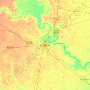
Nom : Carte topographique Sultanpur, altitude, relief.
Lieu : Sultanpur, Uttar Pradesh, 228001, India (26.09886 81.91169 26.41886 82.23169)
Altitude moyenne : 97 m
Altitude minimum : 78 m
Altitude maximum : 107 m