
Carte topographique Lac Hall
Carte interactive
Cliquez sur la carte pour afficher l’altitude.
À propos de cette carte
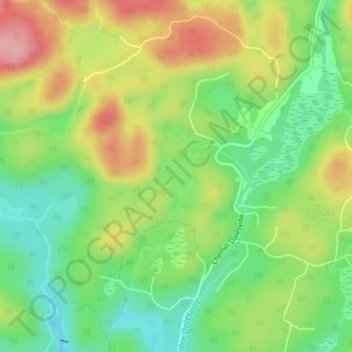
Nom : Carte topographique Lac Hall, altitude, relief.
Altitude moyenne : 229 m
Altitude minimum : 175 m
Altitude maximum : 298 m
Autres cartes topographiques
Cliquez sur une carte pour visualiser sa topographie, son altitude et son relief.
Lac Crooks
Canada > Québec > Brownsburg-Chatham
Lac Crooks, Brownsburg-Chatham, Argenteuil, Laurentides, Québec, Canada
Altitude moyenne : 205 m
Lac Carillon
Canada > Québec > Brownsburg-Chatham
Lac Carillon, Rue du Progrès, Brownsburg-Chatham, Argenteuil, Laurentides, Québec, J8G 3C4, Canada
Altitude moyenne : 185 m
Dunany
Canada > Québec > Brownsburg-Chatham
Dunany, Brownsburg-Chatham, Argenteuil, Laurentides, Québec, Canada
Altitude moyenne : 256 m
Cushing
Canada > Québec > Brownsburg-Chatham > Cushing
Cushing, Brownsburg-Chatham, Argenteuil, Laurentides, Québec, K0B 1B0, Canada
Altitude moyenne : 57 m
Lac à Moore
Canada > Québec > Brownsburg-Chatham
Lac à Moore, Chemin de Via-Veneto, Brownsburg-Chatham, Argenteuil, Laurentides, Québec, J8G 1E4, Canada
Altitude moyenne : 277 m
Petit lac Grenville
Canada > Québec > Brownsburg-Chatham
Petit lac Grenville, Chemin d'Andernach, Brownsburg-Chatham, Argenteuil, Laurentides, Québec, J8G 1E4, Canada
Altitude moyenne : 295 m