
Carte topographique Nakuru
Carte interactive
Cliquez sur la carte pour afficher l’altitude.
Nakuru
On 3 June 2021, Nakuru was officially endorsed for city status after the Kenyan Senate voted for its elevation from a Municipality. The President of the Republic of Kenya will need to give a city charter for official transformation to city status. If and once given the charter, Nakuru will be the fourth city of Kenya after Nairobi city, Mombasa city and Kisumu city.
À propos de cette carte
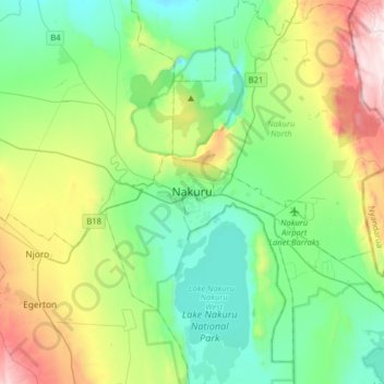
Nom : Carte topographique Nakuru, altitude, relief.
Lieu : Nakuru, Kenya (-0.44027 35.91120 -0.12027 36.23120)
Altitude moyenne : 1 993 m
Altitude minimum : 1 717 m
Altitude maximum : 2 703 m