
Carte topographique Smithson Valley
Carte interactive
Cliquez sur la carte pour afficher l’altitude.
À propos de cette carte
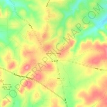
Nom : Carte topographique Smithson Valley, altitude, relief.
Lieu : Smithson Valley, Comal County, Texas, 78131, United States (29.79300 -98.35724 29.83300 -98.31724)
Altitude moyenne : 388 m
Altitude minimum : 335 m
Altitude maximum : 431 m
Autres cartes topographiques
Cliquez sur une carte pour visualiser sa topographie, son altitude et son relief.
Canyon Lake
United States > Texas > Comal County
Canyon Lake, Comal County, Texas, 78133, United States
Altitude moyenne : 296 m
New Braunfels
United States > Texas > Comal County
New Braunfels, Comal County, Texas, United States
Altitude moyenne : 228 m
Spring Branch
United States > Texas > Comal County
Spring Branch, Comal County, Texas, United States
Altitude moyenne : 348 m
Bulverde
United States > Texas > Comal County
Bulverde, Comal County, Texas, United States
Altitude moyenne : 364 m
Rivercrest Heights
United States > Texas > Comal County > New Braunfels
Rivercrest Heights, New Braunfels, Comal County, Texas, 78130, United States
Altitude moyenne : 202 m
villas pool
United States > Texas > Comal County > Bulverde
villas pool, Bulverde, Comal County, Texas, United States
Altitude moyenne : 378 m
Oak Run
United States > Texas > Comal County > New Braunfels
Oak Run, New Braunfels, Comal County, Texas, 78132, United States
Altitude moyenne : 254 m
Cranes Mill
United States > Texas > Comal County
Cranes Mill, Comal County, Texas, United States
Altitude moyenne : 361 m
Fair Oaks Ranch
United States > Texas > Comal County
Fair Oaks Ranch, Comal County, Texas, United States
Altitude moyenne : 409 m
Garden Ridge
United States > Texas > Comal County
Garden Ridge, Comal County, Texas, 78266, United States
Altitude moyenne : 263 m
Woodrow
United States > Texas > Comal County > New Braunfels
Woodrow, New Braunfels, Comal County, Texas, 78130, United States
Altitude moyenne : 219 m
Bulverde
United States > Texas > Comal County
Bulverde, Comal County, Texas, United States
Altitude moyenne : 364 m
Sattler
United States > Texas > Comal County
Sattler, Comal County, Texas, United States
Altitude moyenne : 265 m
Gruene
United States > Texas > Comal County > New Braunfels
Gruene, New Braunfels, Comal County, Texas, 78135, United States
Altitude moyenne : 210 m
Thorn Hill
United States > Texas > Comal County > New Braunfels
Thorn Hill, New Braunfels, Comal County, Texas, 78135, United States
Altitude moyenne : 213 m
Glenbrook
United States > Texas > Comal County > New Braunfels
Glenbrook, New Braunfels, Comal County, Texas, 78130, United States
Altitude moyenne : 201 m
Freiheit
United States > Texas > Comal County > New Braunfels
Freiheit, New Braunfels, Comal County, Texas, 78135, United States
Altitude moyenne : 204 m
Royal Forest
United States > Texas > Comal County > Royal Forest
Royal Forest, Comal County, Texas, United States
Altitude moyenne : 306 m
Fischer
United States > Texas > Comal County
Fischer, Comal County, Texas, 78623, United States
Altitude moyenne : 363 m
Summerwood
United States > Texas > Comal County > New Braunfels > Summerwood
Summerwood, New Braunfels, Comal County, Texas, 78130, United States
Altitude moyenne : 200 m