Géolocaliser

Carte topographique 달터마을

Cliquez sur la carte pour afficher l’altitude.

👉 Easily get elevation data in JSON, GeoTIFF and KML formats using Elevation API
Merci de soutenir ce site ❤️
Faire un don

À propos de cette carte

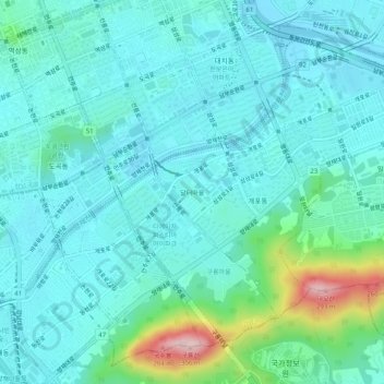
Nom : Carte topographique 달터마을, altitude, relief.

Lieu : 달터마을, Gaepo 2(i)-dong, Gangnam-gu, Seoul, 06324, South Korea (37.46506 127.04143 37.50506 127.08143)

Altitude moyenne : 54 m

Altitude minimum : 7 m

Altitude maximum : 276 m

Autres cartes topographiques

Cliquez sur une carte pour visualiser sa topographie, son altitude et son relief.

Dongjak-gu

South Korea > Seoul

Altitude moyenne : 42 m

Seoul

South Korea > Seoul

Altitude moyenne : 71 m

Seogyo-dong

South Korea > Seoul

Altitude moyenne : 25 m

Heukseok-dong

South Korea > Seoul

Altitude moyenne : 45 m

Gangnam-gu

South Korea > Seoul

Altitude moyenne : 44 m

Jungnang-gu

South Korea > Seoul

Altitude moyenne : 65 m

Seoul

South Korea > Seoul > Jung-gu

Altitude moyenne : 56 m

Sadang-dong

South Korea > Seoul

Altitude moyenne : 57 m

Cheonggyecheon (Stream)

South Korea > Seoul

Altitude moyenne : 32 m

Seodaemun-gu

South Korea > Seoul

Seodaemun District incorporates residential areas and historical areas including Bongwon Temple, Sinchon Railway Station (the oldest train station in Seoul) and Seodaemun Prison History Hall. Also it has a historic culture site "Seodaemun Independence Park." This place located at Dongnimmun station, includes a…

Altitude moyenne : 70 m

Mapo-gu

South Korea > Seoul

Altitude moyenne : 33 m

Gangnam-gu

South Korea > Seoul

Altitude moyenne : 44 m

Hannam-dong

South Korea > Seoul

Altitude moyenne : 59 m

Cheonggyecheon (Stream)

South Korea > Seoul

Altitude moyenne : 30 m

Seongbuk-gu

South Korea > Seoul

Altitude moyenne : 108 m

Gangnam-gu

South Korea > Seoul

Altitude moyenne : 44 m

Gangnam-gu

South Korea > Seoul

Altitude moyenne : 44 m

Buam-dong

South Korea > Seoul

Altitude moyenne : 139 m

Yeokchon-dong

South Korea > Seoul

Altitude moyenne : 53 m

Yongsan-gu

South Korea > Seoul

Yongsan is located next to the Han River, with level ground in the west of the district which has been used for transportation (rail) and commercial use since the early 20th century. To the east and north in the land is steeper and rises towards Namsan which lies to the north. Namsan has an elevation of 243m…

Altitude moyenne : 39 m

Seongbuk-gu

South Korea > Seoul

Altitude moyenne : 108 m

Gangseo-gu

South Korea > Seoul

Altitude moyenne : 22 m

Dongdaemun-gu

South Korea > Seoul

Altitude moyenne : 36 m

Seocho-gu

South Korea > Seoul

Altitude moyenne : 75 m

Gwanak-gu

South Korea > Seoul

Altitude moyenne : 138 m

Gwangjin-gu

South Korea > Seoul

Altitude moyenne : 40 m

Seocho-gu

South Korea > Seoul

Altitude moyenne : 75 m

Nowon-gu

South Korea > Seoul

Altitude moyenne : 99 m

Songpa-gu

South Korea > Seoul

Altitude moyenne : 34 m

Cheonggyecheon (Stream)

South Korea > Seoul

Altitude moyenne : 30 m

Yangcheon-gu

South Korea > Seoul

Altitude moyenne : 23 m

Seongdong-gu

South Korea > Seoul

Altitude moyenne : 28 m

Gwangjin-gu

South Korea > Seoul

Altitude moyenne : 40 m

Jongno-gu

South Korea > Seoul

Jongno district was historically the center of Joseon & latterly the Korean Empire and retained its prominence in the modern era after the establishment of the Republic of Korea. Hanyang, the capital of Joseon, included Jongno district and Jung district. In October, 1394 (the third year of King Taejo's reign),…

Altitude moyenne : 143 m

Songpa-gu

South Korea > Seoul

Altitude moyenne : 34 m

Guro-gu

South Korea > Seoul

Altitude moyenne : 28 m

Guro-gu

South Korea > Seoul

Altitude moyenne : 28 m

Jungnang-gu

South Korea > Seoul

Altitude moyenne : 65 m

Gangbuk-gu

South Korea > Seoul

Altitude moyenne : 139 m

Mapo-gu

South Korea > Seoul

Altitude moyenne : 33 m

Dongdaemun-gu

South Korea > Seoul

Altitude moyenne : 36 m

Jung-gu

South Korea > Seoul

Altitude moyenne : 52 m

Sangam-dong

South Korea > Seoul

Altitude moyenne : 22 m

Gwangjin-gu

South Korea > Seoul

Altitude moyenne : 40 m

Gwangjang-dong

South Korea > Seoul

Altitude moyenne : 43 m

Mapo-gu

South Korea > Seoul

Altitude moyenne : 33 m

Jung-gu

South Korea > Seoul

Altitude moyenne : 52 m

Gangbuk-gu

South Korea > Seoul

Altitude moyenne : 139 m

Seongbuk-gu

South Korea > Seoul

Altitude moyenne : 108 m

Seongbuk-gu

South Korea > Seoul

Altitude moyenne : 108 m

Jungnang-gu

South Korea > Seoul

Altitude moyenne : 65 m

Jamsil Hanriver park

South Korea > Seoul

Altitude moyenne : 17 m

Eunpyeong-gu

South Korea > Seoul

Altitude moyenne : 125 m

Seodaemun-gu

South Korea > Seoul

Seodaemun District incorporates residential areas and historical areas including Bongwon Temple, Sinchon Railway Station (the oldest train station in Seoul) and Seodaemun Prison History Hall. Also it has a historic culture site "Seodaemun Independence Park." This place located at Dongnimmun station, includes a…

Altitude moyenne : 70 m

Jung-gu

South Korea > Seoul

Altitude moyenne : 52 m

Gangdong-gu

South Korea > Seoul

Altitude moyenne : 45 m

Jung-gu

South Korea > Seoul

Altitude moyenne : 52 m

Ssangmun-dong

South Korea > Seoul > Ssangmun-dong

Altitude moyenne : 49 m

Gangseo-gu

South Korea > Seoul

Altitude moyenne : 22 m

Gangnam-gu

South Korea > Seoul

Altitude moyenne : 44 m

Eunpyeong-gu

South Korea > Seoul

Altitude moyenne : 125 m

Yeongdeungpo-gu

South Korea > Seoul

Altitude moyenne : 20 m

Eunpyeong-gu

South Korea > Seoul

Altitude moyenne : 125 m

Yangcheon-gu

South Korea > Seoul

Altitude moyenne : 23 m

Dongjak-gu

South Korea > Seoul

Altitude moyenne : 42 m

Gwanak-gu

South Korea > Seoul

Altitude moyenne : 138 m

Yongsan-gu

South Korea > Seoul

Yongsan is located next to the Han River, with level ground in the west of the district which has been used for transportation (rail) and commercial use since the early 20th century. To the east and north in the land is steeper and rises towards Namsan which lies to the north. Namsan has an elevation of 243m…

Altitude moyenne : 39 m

Songpa-gu

South Korea > Seoul

Altitude moyenne : 34 m

Yongsan-gu

South Korea > Seoul

Yongsan is located next to the Han River, with level ground in the west of the district which has been used for transportation (rail) and commercial use since the early 20th century. To the east and north in the land is steeper and rises towards Namsan which lies to the north. Namsan has an elevation of 243m…

Altitude moyenne : 39 m

Mapo-gu

South Korea > Seoul

Altitude moyenne : 33 m

Seongdong-gu

South Korea > Seoul

Altitude moyenne : 28 m

Jung-gu

South Korea > Seoul

Altitude moyenne : 52 m

Samseong-dong

South Korea > Seoul > Gangnam-gu > Samseong-dong

Altitude moyenne : 35 m

Bangbae-dong

South Korea > Seoul > Seocho-gu > Bangbae-dong

Altitude moyenne : 79 m

Jungnang-gu

South Korea > Seoul

Altitude moyenne : 65 m

Jongno-gu

South Korea > Seoul

Jongno district was historically the center of Joseon & latterly the Korean Empire and retained its prominence in the modern era after the establishment of the Republic of Korea. Hanyang, the capital of Joseon, included Jongno district and Jung district. In October, 1394 (the third year of King Taejo's reign),…

Altitude moyenne : 143 m

Jung-gu

South Korea > Seoul

Altitude moyenne : 52 m

Seodaemun-gu

South Korea > Seoul

Seodaemun District incorporates residential areas and historical areas including Bongwon Temple, Sinchon Railway Station (the oldest train station in Seoul) and Seodaemun Prison History Hall. Also it has a historic culture site "Seodaemun Independence Park." This place located at Dongnimmun station, includes a…

Altitude moyenne : 70 m

Songpa-gu

South Korea > Seoul

Altitude moyenne : 34 m

Dobong-gu

South Korea > Seoul

Altitude moyenne : 120 m

Gwangjin-gu

South Korea > Seoul

Altitude moyenne : 40 m

Pyeongchang-dong

South Korea > Seoul

Altitude moyenne : 268 m

Yeonhui-dong

South Korea > Seoul

Altitude moyenne : 56 m

Geumcheon-gu

South Korea > Seoul

Altitude moyenne : 56 m

Équipez-vous pour votre prochaine aventure :

🕶️Lunettes de soleil polarisées - Protection UV essentielle pour la haute altitude et les reflets sur la neige
🔥Allume-feu de survie - Tige de ferrocerium pour démarrer un feu même dans des conditions humides
🧴Baume à lèvres SPF 30 - Évitez les lèvres gercées par le vent et le soleil de montagne
🔋Batteries externes outdoor - Recharge des appareils en pleine nature
🍲Repas lyophilisés pour camping - Nourriture légère et nutritive pour les longues randonnées

En tant que Partenaire Amazon, ce site perçoit une commission sur les achats éligibles sans surcoût pour vous.