
Carte topographique Courmayeur
Carte interactive
Cliquez sur la carte pour afficher l’altitude.
À propos de cette carte
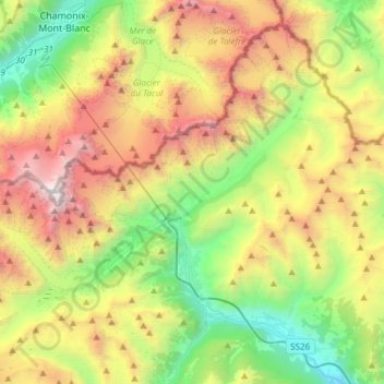
Nom : Carte topographique Courmayeur, altitude, relief.
Lieu : Courmayeur, Aosta Valley, 11013, Italy (45.74005 6.80153 45.92302 7.10155)
Altitude moyenne : 2 366 m
Altitude minimum : 819 m
Altitude maximum : 4 800 m
At an elevation of 1,224 m (4,016 ft) above sea level, it is located at the foot of the southern side of Mont Blanc, at 4,810 m (15,781 ft) the highest point in the Alps and western Europe (see Seven Summits), and is crossed by the Dora Baltea (fr. Doire baltée) river.
Autres cartes topographiques
Cliquez sur une carte pour visualiser sa topographie, son altitude et son relief.
Saint-Rhémy-en-Bosses
Saint-Rhémy-en-Bosses, Aosta Valley, Italy
Altitude moyenne : 2 181 m
Paquier
Italy > Aosta Valley > Saint-Marcel
Paquier, Saint-Marcel, Aosta Valley, Italy
Altitude moyenne : 718 m
Evian
Italy > Aosta Valley > Saint-Nicolas
Evian, Saint-Nicolas, Aosta Valley, 11018, Italy
Altitude moyenne : 1 022 m
Ghiacciaio di Cherillon
Italy > Aosta Valley > Valtournenche
Ghiacciaio di Cherillon, Valtournenche, Aosta Valley, Italy
Altitude moyenne : 3 155 m
Chevril
Italy > Aosta Valley > Aymavilles
Chevril, Aymavilles, Aosta Valley, 11010, Italy
Altitude moyenne : 1 428 m
Lillaz
Lillaz, Antey-Saint-André, Aosta Valley, 11020, Italy
Altitude moyenne : 1 545 m
Le Pont
Italy > Aosta Valley > Valsavarenche
Le Pont, Valsavarenche, Aosta Valley, Italy
Altitude moyenne : 2 410 m
Liex
Italy > Aosta Valley > Epaillon
Liex, Epaillon, Antey-Saint-André, Aosta Valley, 11020, Italy
Altitude moyenne : 1 327 m
Parco Naturale del Mont Avic
Italy > Aosta Valley > Champdepraz
Parco Naturale del Mont Avic, Champdepraz, Aosta Valley, Italy
Altitude moyenne : 2 081 m
Castello Gamba
Italy > Aosta Valley > Châtillon > Sétoret
Castello Gamba, Strada Comunale Cret De Breil, Sétoret, Châtillon, Aosta Valley, 11024, Italy
Altitude moyenne : 687 m
Gros-Breil
Italy > Aosta Valley > Châtillon
Gros-Breil, Châtillon, Aosta Valley, 11024, Italy
Altitude moyenne : 845 m
Pussey
Italy > Aosta Valley > Courmayeur
Pussey, Courmayeur, Aosta Valley, 11013, Italy
Altitude moyenne : 1 561 m
Lago di Place Moulin
Lago di Place Moulin, Bionaz, Aosta Valley, Italy
Altitude moyenne : 2 297 m
Mont du Clapey
Italy > Aosta Valley > Oyace
Mont du Clapey, Oyace, Aosta Valley, Italy
Altitude moyenne : 2 748 m
Mont d'Ars
Italy > Aosta Valley > Gignod
Mont d'Ars, Gignod, Aosta Valley, 11014, Italy
Altitude moyenne : 2 456 m
Alpe Chomioi
Italy > Aosta Valley > Torgnon
Alpe Chomioi, Torgnon, Aosta Valley, Italy
Altitude moyenne : 2 307 m
Pic Eccles
Italy > Aosta Valley > Courmayeur
Pic Eccles, Courmayeur, Aosta Valley, Italy
Altitude moyenne : 3 722 m
Le Breuil - Cervinia
Le Breuil - Cervinia, Valtournenche, Aosta Valley, 11021, Italy
Altitude moyenne : 2 376 m
Testa d'Arpy
Italy > Aosta Valley > Morgex
Testa d'Arpy, Morgex, Aosta Valley, 11017, Italy
Altitude moyenne : 1 651 m
Ostafa Desot
Italy > Aosta Valley > Ayas
Ostafa Desot, Ayas, Aosta Valley, 11020, Italy
Altitude moyenne : 2 275 m
Cotes
Italy > Aosta Valley > Gressan
Cotes, Gressan, Aosta Valley, 11100, Italy
Altitude moyenne : 981 m
Fiernaz Dessous
Fiernaz Dessous, Antey-Saint-André, Aosta Valley, 11020, Italy
Altitude moyenne : 1 599 m
Monte Rosa Massif
Italy > Aosta Valley > Gressoney-La-Trinité
Monte Rosa Massif, Gressoney-La-Trinité, Aosta Valley, Italy
Altitude moyenne : 3 478 m
Edelboden inferiore
Italy > Aosta Valley > Gressoney-La-Trinité
Edelboden inferiore, Gressoney-La-Trinité, Aosta Valley, Italy
Altitude moyenne : 2 167 m
Entrèves
Italy > Aosta Valley > Courmayeur
Entrèves, Courmayeur, Aosta Valley, 11013, Italy
Altitude moyenne : 1 702 m
Saint-Vincent
Saint-Vincent, Aosta Valley, 11027, Italy
Altitude moyenne : 1 179 m
Paquier
Italy > Aosta Valley > Gressan > Paquier
Paquier, Gressan, Aosta Valley, 11100, Italy
Altitude moyenne : 801 m
Gran Paradiso
Italy > Aosta Valley > Valsavarenche
Gran Paradiso, Valsavarenche, Aosta Valley, Italy
Altitude moyenne : 3 459 m
Planet
Italy > Aosta Valley > Donnas > Planet
Planet, Donnas, Aosta Valley, 11020, Italy
Altitude moyenne : 794 m
Larzey
Italy > Aosta Valley > Courmayeur > Larzey
Larzey, Courmayeur, Aosta Valley, 11013, Italy
Altitude moyenne : 1 596 m
Chopine
Italy > Aosta Valley > Torille > Chopine
Chopine, Torille, Verrès, Aosta Valley, 11029, Italy
Altitude moyenne : 610 m
Clavon
Italy > Aosta Valley > Verrayes > Clavon
Clavon, Verrayes, Aosta Valley, Italy
Altitude moyenne : 1 574 m
Gressoney-Saint-Jean
Gressoney-Saint-Jean, Aosta Valley, 11025, Italy
Altitude moyenne : 2 179 m
Weissmatten
Italy > Aosta Valley > Gressoney-Saint-Jean
Weissmatten, Gressoney-Saint-Jean, Aosta Valley, 11025, Italy
Altitude moyenne : 1 932 m
Lago Gabiet
Italy > Aosta Valley > Gressoney-La-Trinité
Lago Gabiet, 5, Batt, Gressoney-La-Trinité, Aosta Valley, Italy
Altitude moyenne : 2 433 m
Torrente
Italy > Aosta Valley > Bionaz
Torrente, Bionaz, Aosta Valley, Italy
Altitude moyenne : 2 448 m