
Carte topographique Fox Creek
Cliquez sur la carte pour afficher l’altitude.
Fox Creek
Fox Creek is a town in northwest Alberta, Canada. It is located on Highway 43, approximately 259 km (161 mi) northwest of Edmonton and 199 km (124 mi) southeast of Grande Prairie, and has an elevation of 808 m (2,651 ft).
À propos de cette carte
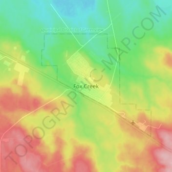
Nom : Carte topographique Fox Creek, altitude, relief.
Lieu : Fox Creek, Town of Fox Creek, Alberta, T0H 1P0, Canada (54.35721 -116.84338 54.43721 -116.76338)
Altitude moyenne : 834 m
Altitude minimum : 776 m
Altitude maximum : 913 m