
Faire un don
Équipez-vous pour votre prochaine aventure :
En tant que Partenaire Amazon, ce site perçoit une commission sur les achats éligibles sans surcoût pour vous.
Carte topographique Dinosaur National Monument
Cliquez sur la carte pour afficher l’altitude.
Faire un don
Équipez-vous pour votre prochaine aventure :
En tant que Partenaire Amazon, ce site perçoit une commission sur les achats éligibles sans surcoût pour vous.
Dinosaur National Monument
Originally preserved in 1915 to protect its famous Dinosaur Quarry, the monument was greatly expanded in 1938 to include its wealth of natural history. The park's wild landscapes, topography, geology, paleontology, and history make it a unique resource for both science and recreation. The park contains over 800 paleontological sites and has fossils of dinosaurs including Allosaurus, Deinonychus, Abydosaurus, and various sauropods. The Abydosaurus consists of a nearly complete skull, the lower jaw, and first four neck vertebrae. The specimen was found at the base of the Mussentuchit Member of the Cedar Mountain Formation and is the holotype for the description.
Faire un don
Équipez-vous pour votre prochaine aventure :
En tant que Partenaire Amazon, ce site perçoit une commission sur les achats éligibles sans surcoût pour vous.
À propos de cette carte
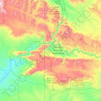
Nom : Carte topographique Dinosaur National Monument, altitude, relief.
Altitude moyenne : 1 988 m
Altitude minimum : 1 437 m
Altitude maximum : 2 955 m
Faire un don
Équipez-vous pour votre prochaine aventure :
En tant que Partenaire Amazon, ce site perçoit une commission sur les achats éligibles sans surcoût pour vous.
Autres cartes topographiques
Cliquez sur une carte pour visualiser sa topographie, son altitude et son relief.