
Carte topographique Gudauri
Carte interactive
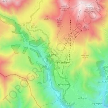
Cliquez sur la carte pour afficher l’altitude.
À propos de cette carte
Nom : Carte topographique Gudauri, altitude, relief.
Altitude moyenne : 2 258 m
Altitude minimum : 1 429 m
Altitude maximum : 3 303 m
Gudauri (Georgian: გუდაური) is a ski resort located on the south-facing plateau of The Greater Caucasus Mountain Range in Georgia. The resort is situated in the Stepantsminda District, along the Georgian Military Highway near the Jvari Pass, at an elevation of 2,200 meters (7,200 ft.) above sea level. Gudauri lies 120 km (75 mi) to the north of the Georgian capital Tbilisi. The resort offers high quality skiing opportunities. The slopes of Gudauri are above the tree line and considered to be avalanche-safe. The ski season lasts from December to April. Heliskiing is available throughout the season.
Autres cartes topographiques
Cliquez sur une carte pour visualiser sa topographie, son altitude et son relief.
Stepantsminda
Georgia > Mtskheta-Mtianeti > Kazbegi Municipality
Stepantsminda, Kazbegi Municipality, Mtskheta-Mtianeti, 0470, Georgia
Altitude moyenne : 2 361 m
Chata
Georgia > Mtskheta-Mtianeti > Kazbegi Municipality
Chata, Kazbegi Municipality, Mtskheta-Mtianeti, Georgia
Altitude moyenne : 3 463 m
Kazbegi
Georgia > Mtskheta-Mtianeti > Kazbegi Municipality
Kazbegi, Kazbegi Municipality, Mtskheta-Mtianeti, Georgia
Altitude moyenne : 4 324 m