
Faire un don
Équipez-vous pour votre prochaine aventure :
En tant que Partenaire Amazon, ce site perçoit une commission sur les achats éligibles sans surcoût pour vous.
Carte topographique San Ysidro
Cliquez sur la carte pour afficher l’altitude.
Faire un don
Équipez-vous pour votre prochaine aventure :
En tant que Partenaire Amazon, ce site perçoit une commission sur les achats éligibles sans surcoût pour vous.
À propos de cette carte
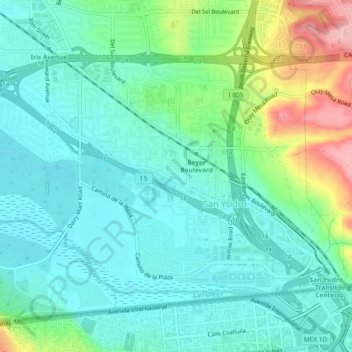
Nom : Carte topographique San Ysidro, altitude, relief.
Altitude moyenne : 42 m
Altitude minimum : 3 m
Altitude maximum : 156 m
Faire un don
Équipez-vous pour votre prochaine aventure :
En tant que Partenaire Amazon, ce site perçoit une commission sur les achats éligibles sans surcoût pour vous.
Autres cartes topographiques
Cliquez sur une carte pour visualiser sa topographie, son altitude et son relief.
San Diego
United States > California > San Diego County > San Diego
The climate in San Diego, like most of Southern California, often varies significantly over short geographical distances, resulting in microclimates. In San Diego, this is mostly because of the city's topography (the Bay, and the numerous hills, mountains, and canyons). Frequently, particularly during the "May…
Altitude moyenne : 57 m
Mission Trails Regional Park
United States > California > San Diego County > San Diego
Altitude moyenne : 154 m
Faire un don
Équipez-vous pour votre prochaine aventure :
En tant que Partenaire Amazon, ce site perçoit une commission sur les achats éligibles sans surcoût pour vous.
South Encanto
United States > California > San Diego County > San Diego > South Encanto
Altitude moyenne : 80 m
Faire un don
Équipez-vous pour votre prochaine aventure :
En tant que Partenaire Amazon, ce site perçoit une commission sur les achats éligibles sans surcoût pour vous.
Colina Park
United States > California > San Diego County > San Diego > Colina Park
Altitude moyenne : 110 m
Valencia Park
United States > California > San Diego County > San Diego > Valencia Park
Altitude moyenne : 56 m
Alta Vista
United States > California > San Diego County > San Diego > Alta Vista
Altitude moyenne : 81 m
Faire un don
Équipez-vous pour votre prochaine aventure :
En tant que Partenaire Amazon, ce site perçoit une commission sur les achats éligibles sans surcoût pour vous.
Embarcadero Marina Park
United States > California > San Diego County > San Diego
Altitude moyenne : 7 m
Old Town San Diego State Historical Park
United States > California > San Diego County > San Diego
Altitude moyenne : 18 m
Faire un don
Équipez-vous pour votre prochaine aventure :
En tant que Partenaire Amazon, ce site perçoit une commission sur les achats éligibles sans surcoût pour vous.