Géolocaliser

Carte topographique Mount Banks

Cliquez sur la carte pour afficher l’altitude.

Mount Banks

Mount Banks, otherwise known as Mount King George, is a mountain within the Explorers Range of the Blue Mountains Range that is a spur off the Great Dividing Range, is located within the Blue Mountains National Park, approximately 100 kilometres (62 mi) west of Sydney in New South Wales, Australia. Mount Banks is located 8 kilometres (5.0 mi) from the nearest residential area, Mount Tomah, has an elevation of 1,049 metres (3,442 ft) AMSL, and can be accessed relatively easily via the Bells Line of Road.

Wikipedia (CC-BY-SA 3.0)

À propos de cette carte

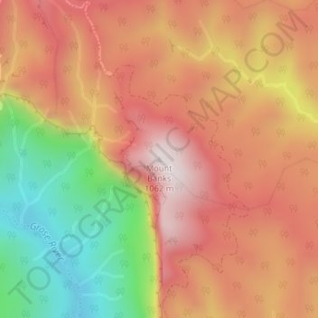
Nom : Carte topographique Mount Banks, altitude, relief.

Lieu : Mount Banks, Blue Mountains City Council, New South Wales, Australia (-33.58690 150.36958 -33.58680 150.36968)

Altitude moyenne : 745 m

Altitude minimum : 330 m

Altitude maximum : 1 041 m

Autres cartes topographiques

Cliquez sur une carte pour visualiser sa topographie, son altitude et son relief.

Sydney

Australia > New South Wales

Sydney's topography is characterized by a diverse landscape that seamlessly blends coastal features with inland plateaus. The city is divided into two primary regions: the relatively flat Cumberland Plain to the south and west of Sydney Harbour, and the elevated Hornsby Plateau to the north. The Cumberland…

Altitude moyenne : 53 m

Newcastle

Australia > New South Wales

Altitude moyenne : 5 m

Fingal Head

Australia > New South Wales

Altitude moyenne : 4 m

Sydney

Australia > New South Wales > Sydney

Altitude moyenne : 23 m

Northern Beaches

Australia > New South Wales > Sydney

Altitude moyenne : 67 m

Baulkham Hills

Australia > New South Wales

Altitude moyenne : 93 m

Edmondson Park

Australia > New South Wales > Sydney

Altitude moyenne : 56 m

Bowral

Australia > New South Wales

Altitude moyenne : 690 m

Katoomba

Australia > New South Wales

Altitude moyenne : 904 m

Manly Vale

Australia > New South Wales > Sydney

Altitude moyenne : 34 m

Cronulla

Australia > New South Wales > Sydney

Altitude moyenne : 8 m

Lismore

Australia > New South Wales

Altitude moyenne : 23 m

Glen Innes

Australia > New South Wales

Altitude moyenne : 1 083 m

Nimbin

Australia > New South Wales

Altitude moyenne : 235 m

Portland

Australia > New South Wales

At an altitude of 925 metres above sea level, Portland is the 21st highest town in Australia and classified as a temperate zone. Cool winters and warm summers ensure four distinct seasons and snowfalls each winter.

Altitude moyenne : 972 m

River Lett

Australia > New South Wales

Altitude moyenne : 804 m

Penrith

Australia > New South Wales > Sydney > Penrith

Penrith is a city in New South Wales, Australia, located in Greater Western Sydney, 55 kilometres (31 mi) west of the Sydney central business district on the banks of the Nepean River, on the outskirts of the Cumberland Plain. Its elevation is 32 metres (105 ft).

Altitude moyenne : 34 m

Redfern

Australia > New South Wales

Altitude moyenne : 30 m

Chatswood

Australia > New South Wales

Altitude moyenne : 81 m

Vaucluse

Australia > New South Wales > Sydney

Altitude moyenne : 20 m

Wauchope

Australia > New South Wales

Altitude moyenne : 32 m

Bundeena

Australia > New South Wales > Sydney

Altitude moyenne : 20 m

Gulmarrad

Australia > New South Wales

Altitude moyenne : 10 m

Braidwood

Australia > New South Wales

Altitude moyenne : 674 m

North Rocks

Australia > New South Wales

Altitude moyenne : 80 m

Horsley Park

Australia > New South Wales

Altitude moyenne : 79 m

Cooranbong

Australia > New South Wales

Altitude moyenne : 72 m

Mollymook

Australia > New South Wales

Altitude moyenne : 24 m

Moss Vale

Australia > New South Wales

Altitude moyenne : 673 m

Erina

Australia > New South Wales

Altitude moyenne : 46 m

Gorokan

Australia > New South Wales

Altitude moyenne : 7 m

Ku-ring-gai Chase National Park

Australia > New South Wales > Sydney

Ku-ring-gai Chase is part of the Hornsby Plateau, a massive block of sandstone tilting upwards to the north. The park comprises a plateau with an elevation of generally 150–200 m above sea level. Between 250 and 200 million years ago, sand silt and mud was deposited by rivers across flood plains. These…

Altitude moyenne : 83 m

Vacy

Australia > New South Wales

Altitude moyenne : 88 m

Forster

Australia > New South Wales

Altitude moyenne : 5 m

Wardell

Australia > New South Wales

Altitude moyenne : 10 m

Lawrence

Australia > New South Wales

Altitude moyenne : 25 m

Bilambil Heights

Australia > New South Wales

Altitude moyenne : 41 m

Oakdale

Australia > New South Wales

Altitude moyenne : 345 m

Eastern Creek

Australia > New South Wales

Altitude moyenne : 60 m

Uriarra

Australia > New South Wales

Altitude moyenne : 808 m

Wyndham

Australia > New South Wales

Altitude moyenne : 391 m

Goonoo Goonoo

Australia > New South Wales

Altitude moyenne : 471 m

Bass Hill

Australia > New South Wales

Altitude moyenne : 35 m

Balmain

Australia > New South Wales > Sydney

Altitude moyenne : 12 m

Botany

Australia > New South Wales > Sydney

Altitude moyenne : 6 m

Waverley

Australia > New South Wales > Sydney

Waverley Council takes its name from the suburb but its administrative centre is located in the adjacent suburb of Bondi Junction, which is also a major commercial centre. Waverley is the highest point of altitude in Sydney's Eastern Suburbs.

Altitude moyenne : 60 m

Sydney CBD

Australia > New South Wales > Sydney

Altitude moyenne : 25 m

Armidale

Australia > New South Wales

Altitude moyenne : 1 036 m

Byron Bay

Australia > New South Wales

Byron Bay, located in northeastern New South Wales, Australia, is characterized by diverse topography shaped by its geological history. The town is part of the erosion caldera of the ancient Tweed Volcano, which erupted approximately 23 million years ago, resulting in the rich volcanic soils that define the…

Altitude moyenne : 7 m

Northmead

Australia > New South Wales

Altitude moyenne : 52 m

Lilyfield

Australia > New South Wales > Sydney

Altitude moyenne : 18 m

Robertson

Australia > New South Wales

Altitude moyenne : 545 m

Glenfield

Australia > New South Wales > Sydney

Altitude moyenne : 29 m

Swansea

Australia > New South Wales

Altitude moyenne : 7 m

King Creek

Australia > New South Wales > Wauchope > King Creek

Altitude moyenne : 6 m

Llandilo

Australia > New South Wales > Sydney

Altitude moyenne : 36 m

Ocean Shores

Australia > New South Wales

Altitude moyenne : 12 m

Pitt Town

Australia > New South Wales

Altitude moyenne : 19 m

Banora Point

Australia > New South Wales

Altitude moyenne : 17 m

Rosehill

Australia > New South Wales > Sydney

Altitude moyenne : 9 m

Orange

Australia > New South Wales

Orange is a city in the Central Tablelands region of New South Wales, Australia. It is 254 km (158 mi) west of the state capital, Sydney [206 km (128 mi) on a great circle], at an altitude of 862 metres (2,828 ft). Orange had an estimated urban population of 40,493 as of June 2018 making the city a significant…

Altitude moyenne : 852 m

Maitland

Australia > New South Wales

Altitude moyenne : 11 m

Jiggi

Australia > New South Wales

Altitude moyenne : 105 m

Mulbring

Australia > New South Wales

Altitude moyenne : 96 m

North Albury

Australia > New South Wales > Albury

Altitude moyenne : 179 m

Blowering Dam

Australia > New South Wales > Blowering

Altitude moyenne : 405 m

Inner West Council

Australia > New South Wales > Sydney

Altitude moyenne : 19 m

Berry

Australia > New South Wales

Altitude moyenne : 38 m

Rock Valley

Australia > New South Wales

Altitude moyenne : 92 m

Mooral Creek

Australia > New South Wales

Altitude moyenne : 247 m

Goulburn

Australia > New South Wales

Owing to its elevation, Goulburn has an oceanic climate (Cfb) with warm summers and cool winters; with a high diurnal range. Its climate is variable much of the year, though generally dry with maximum temperatures ranging from 11.8 °C (53.2 °F) in July to 28.3 °C (82.9 °F) in January. Rainfall is…

Altitude moyenne : 666 m

Port Macquarie

Australia > New South Wales

Altitude moyenne : 5 m

Rutherford

Australia > New South Wales

Altitude moyenne : 23 m

Medlow Bath

Australia > New South Wales

Medlow Bath (postcode: 2780) is an Australian small town located near the highest point of the Blue Mountains, between Katoomba and Blackheath. Its altitude is about 1,050 metres (3,440 ft) AHD  and it is about 115 kilometres (71 mi) west-north-west of the Sydney central business district and 5 kilometres…

Altitude moyenne : 930 m

Bangalow

Australia > New South Wales

Altitude moyenne : 83 m

South Grafton

Australia > New South Wales

Altitude moyenne : 36 m

Berridale

Australia > New South Wales

Altitude moyenne : 936 m

Hornsby

Australia > New South Wales > Sydney

Altitude moyenne : 160 m

Talbingo

Australia > New South Wales

Altitude moyenne : 740 m

Wallerawang

Australia > New South Wales

Altitude moyenne : 966 m

Kingscliff

Australia > New South Wales

Altitude moyenne : 5 m

Équipez-vous pour votre prochaine aventure :

🧴Écran solaire sport SPF 50 - Protection contre les rayons UV intenses en montagne
Spray imperméabilisant pour bottes - Prolongez la vie de vos chaussures de randonnée
⛏️Crampons de marche pour glace - Sécurité accrue sur les sentiers gelés ou enneigés
🧂Spray anti-ours - Sécurité en zones sauvages canadiennes
🥾Chaussures de randonnée - Chaussures robustes pour la randonnée et les terrains accidentés

En tant que Partenaire Amazon, ce site perçoit une commission sur les achats éligibles sans surcoût pour vous.