
Carte topographique Horseshoe Bend
Carte interactive
Cliquez sur la carte pour afficher l’altitude.
À propos de cette carte
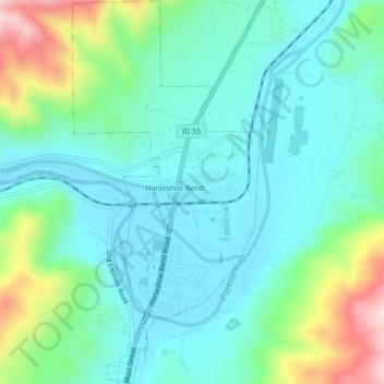
Nom : Carte topographique Horseshoe Bend, altitude, relief.
Lieu : Horseshoe Bend, Boise County, Idaho, United States (43.89845 -116.21011 43.92994 -116.18873)
Altitude moyenne : 867 m
Altitude minimum : 784 m
Altitude maximum : 1 125 m
The area was originally settled as a gold miners' staging area, as prospectors waited along the river for snows to thaw at the higher elevations. Gold had been discovered in 1862 in the Boise Basin mountains to the east, near Idaho City.
Autres cartes topographiques
Cliquez sur une carte pour visualiser sa topographie, son altitude et son relief.
Crouch
United States > Idaho > Boise County
Crouch, Boise County, Idaho, United States
Altitude moyenne : 963 m
Placerville
United States > Idaho > Boise County
Placerville, Boise County, Idaho, 83666, United States
Altitude moyenne : 1 343 m
Hawley Mountain
United States > Idaho > Boise County
Hawley Mountain, Boise County, Idaho, United States
Altitude moyenne : 2 023 m
Idaho City
United States > Idaho > Boise County
Idaho City, Boise County, Idaho, 83631, United States
Altitude moyenne : 1 236 m
North Raker
United States > Idaho > Boise County
North Raker, Boise County, Idaho, United States
Altitude moyenne : 2 651 m
Garden Valley
United States > Idaho > Boise County
Garden Valley, Boise County, Idaho, 83622, United States
Altitude moyenne : 1 004 m