
Carte topographique Swift Trail Junction
Carte interactive
Cliquez sur la carte pour afficher l’altitude.
À propos de cette carte
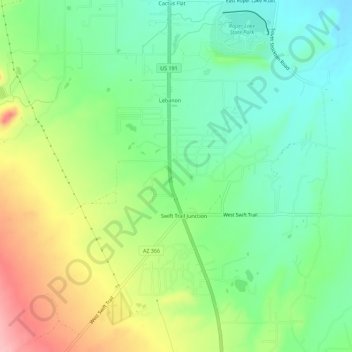
Nom : Carte topographique Swift Trail Junction, altitude, relief.
Altitude moyenne : 984 m
Altitude minimum : 932 m
Altitude maximum : 1 073 m
Swift Trail Junction is a census-designated place (CDP) in Graham County, Arizona, United States. The population was 2,935 at the 2010 census, up from 2,195 in 2000. It is part of the Safford Micropolitan Statistical Area. It is situated at the junction of U.S. Route 191 and State Route 366 (also known as the Swift Trail Parkway). The Swift Trail Parkway is a scenic highway that winds through the Coronado National Forest and provides access to the higher elevations of the Pinaleño Mountains, also known as the Graham Mountains.
Autres cartes topographiques
Cliquez sur une carte pour visualiser sa topographie, son altitude et son relief.
Eden
United States > Arizona > Graham County
Eden, Graham County, Arizona, 85535, United States
Altitude moyenne : 850 m
Thatcher
United States > Arizona > Graham County
Thatcher, Graham County, Arizona, 85552, United States
Altitude moyenne : 912 m
Artesia
United States > Arizona > Graham County
Artesia, Graham County, Arizona, United States
Altitude moyenne : 1 018 m
Mount Graham
United States > Arizona > Graham County
Mount Graham, Graham County, Arizona, United States
Altitude moyenne : 2 957 m
Safford
United States > Arizona > Graham County
Safford, Graham County, Arizona, United States
Altitude moyenne : 912 m
Safford
United States > Arizona > Graham County > Safford
Safford, Graham County, Arizona, 85548, United States
Altitude moyenne : 1 113 m
Thumb Butte
United States > Arizona > Graham County
Thumb Butte, Graham County, Arizona, United States
Altitude moyenne : 1 481 m
Quartzite Mountain
United States > Arizona > Graham County
Quartzite Mountain, Graham County, Arizona, United States
Altitude moyenne : 1 574 m