
Carte topographique Ghazni
Carte interactive
Cliquez sur la carte pour afficher l’altitude.
À propos de cette carte
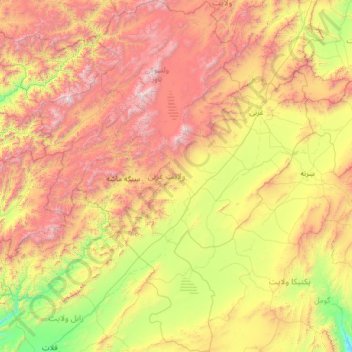
Nom : Carte topographique Ghazni, altitude, relief.
Lieu : Ghazni, Afghanistan (32.07582 66.82336 34.21913 68.82773)
Altitude moyenne : 2 528 m
Altitude minimum : 1 413 m
Altitude maximum : 4 717 m
Autres cartes topographiques
Cliquez sur une carte pour visualiser sa topographie, son altitude et son relief.
Kaboul
Afghanistan > Province de Kaboul > District de Kaboul
Kaboul, District de Kaboul, Province de Kaboul, 1001, Afghanistan
Altitude moyenne : 1 945 m
نادرشاه کوټ ولسوالۍ
نادرشاه کوټ ولسوالۍ, Khôst, Afghanistan
Altitude moyenne : 1 823 m
Lashkar Gah
Afghanistan > Helmand > Lashkar Gah
Lashkar Gah, لښکرگاه, Helmand, Afghanistan
Altitude moyenne : 804 m