
Carte topographique Maltby
Carte interactive
Cliquez sur la carte pour afficher l’altitude.
À propos de cette carte
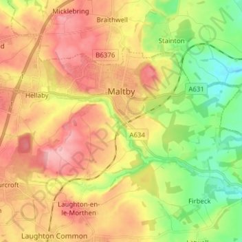
Nom : Carte topographique Maltby, altitude, relief.
Altitude moyenne : 76 m
Altitude minimum : 11 m
Altitude maximum : 154 m
Autres cartes topographiques
Cliquez sur une carte pour visualiser sa topographie, son altitude et son relief.
Wickersley
United Kingdom > England > Rotherham > Bramley
Wickersley, Bramley, Rotherham, South Yorkshire Mayoral Combined Authority, England, United Kingdom
Altitude moyenne : 116 m
Bull Hill
United Kingdom > England > Rotherham
Bull Hill, Rotherham, Yorkshire and the Humber, England, S26 6UY, United Kingdom
Altitude moyenne : 111 m