
Carte topographique Chengguan District
Carte interactive
Cliquez sur la carte pour afficher l’altitude.
À propos de cette carte
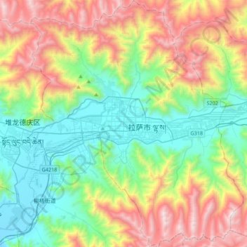
Nom : Carte topographique Chengguan District, altitude, relief.
Lieu : Chengguan District, Lhasa, Tibet, 850000, China (29.51215 91.01220 29.80326 91.30094)
Altitude moyenne : 4 325 m
Altitude minimum : 3 614 m
Altitude maximum : 5 654 m
Lhasa is the second most populous urban area on the Tibetan Plateau after Xining and, at an altitude of 3,656 metres (11,990 ft), Lhasa is one of the highest cities in the world. The city has been the religious and administrative capital of Tibet since the mid-17th century. It contains many culturally significant Tibetan Buddhist sites such as the Potala Palace, Jokhang Temple and Norbulingka Palaces.
Autres cartes topographiques
Cliquez sur une carte pour visualiser sa topographie, son altitude et son relief.
Lhoka
China > Tibet > Tsetang Township
Lhoka, Tsetang Township, Nêdong District, Lhoka, Tibet, China
Altitude moyenne : 4 148 m
Mount Everest
China > Tibet > Qutang > Khumjung
Mount Everest, Qutang, Tingri County, Shigatse, Tibet, China
Altitude moyenne : 7 839 m