
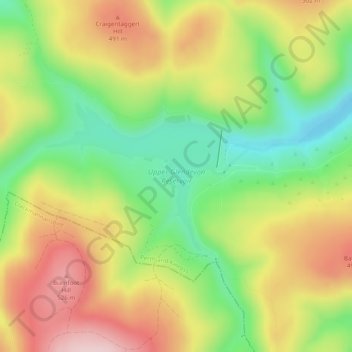
Carte topographique Upper Glendevon Reservoir
Carte interactive
Cliquez sur la carte pour afficher l’altitude.
À propos de cette carte
Nom : Carte topographique Upper Glendevon Reservoir, altitude, relief.
Altitude moyenne : 414 m
Altitude minimum : 291 m
Altitude maximum : 548 m
Autres cartes topographiques
Cliquez sur une carte pour visualiser sa topographie, son altitude et son relief.
Castlehill Reservoir
United Kingdom > Scotland > Perth and Kinross > Glendevon
Castlehill Reservoir, Glendevon, Perth and Kinross, Scotland, United Kingdom
Altitude moyenne : 268 m
Bridge of Earn
United Kingdom > Scotland > Perth and Kinross
Bridge of Earn, Perth and Kinross, Scotland, PH2 9PL, United Kingdom
Altitude moyenne : 70 m
Balbeggie
United Kingdom > Scotland > Perth and Kinross
Balbeggie, Perth and Kinross, Scotland, PH2 6HA, United Kingdom
Altitude moyenne : 119 m
Ochil Hills
United Kingdom > Scotland > Perth and Kinross > Auchterarder
Ochil Hills, Auchterarder, Perth and Kinross, Scotland, United Kingdom
Altitude moyenne : 235 m
Coupar Angus
United Kingdom > Scotland > Perth and Kinross
Coupar Angus, Perth and Kinross, Scotland, PH13 9DA, United Kingdom
Altitude moyenne : 70 m
St Fillans
United Kingdom > Scotland > Perth and Kinross
St Fillans, Perth and Kinross, Scotland, PH6 2ND, United Kingdom
Altitude moyenne : 292 m
Scone
United Kingdom > Scotland > Perth and Kinross
Scone, Perth and Kinross, Scotland, PH2 6SA, United Kingdom
Altitude moyenne : 81 m
Auchterarder
United Kingdom > Scotland > Perth and Kinross
Auchterarder, Perth and Kinross, Scotland, PH3 1BJ, United Kingdom
Altitude moyenne : 128 m
Blairgowrie and Rattray
United Kingdom > Scotland > Perth and Kinross
Blairgowrie and Rattray, Perth and Kinross, Scotland, PH10 6AB, United Kingdom
Altitude moyenne : 121 m
Dunkeld
United Kingdom > Scotland > Perth and Kinross
Dunkeld, Perth and Kinross, Scotland, PH8 0AL, United Kingdom
Altitude moyenne : 190 m
Perth
United Kingdom > Scotland > Perth and Kinross
Perth, Perth and Kinross, Scotland, PH1 5SU, United Kingdom
Altitude moyenne : 131 m
Aberfeldy
United Kingdom > Scotland > Perth and Kinross
Aberfeldy, Perth and Kinross, Scotland, PH15 2DD, United Kingdom
Altitude moyenne : 304 m