
Carte topographique Johannesburg
Carte interactive
Cliquez sur la carte pour afficher l’altitude.
À propos de cette carte
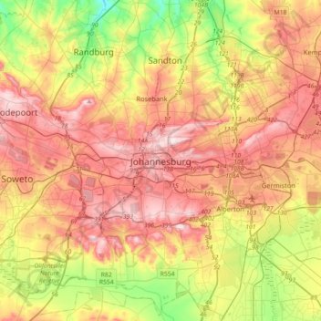
Nom : Carte topographique Johannesburg, altitude, relief.
Altitude moyenne : 1 615 m
Altitude minimum : 1 410 m
Altitude maximum : 1 809 m
Johannesburg is located in the eastern plateau area of South Africa known as the Highveld, at an elevation of 1,753 metres (5,751 ft). The former Central Business District is located on the southern side of the prominent ridge called the Witwatersrand (English: White Water's Ridge) and the terrain falls to the north and south. By and large the Witwatersrand marks the watershed between the Limpopo and Vaal rivers as the northern part of the city is drained by the Jukskei River while the southern part of the city, including most of the Central Business District, is drained by the Klip River. The north and west of the city has undulating hills while the eastern parts are flatter.
Autres cartes topographiques
Cliquez sur une carte pour visualiser sa topographie, son altitude et son relief.
Jukskei River
South Africa > Gauteng > City of Johannesburg Metropolitan Municipality
Jukskei River, City of Johannesburg Metropolitan Municipality, Gauteng, South Africa
Altitude moyenne : 1 528 m
City of Johannesburg Metropolitan Municipality
South Africa > Gauteng > City of Johannesburg Metropolitan Municipality
City of Johannesburg Metropolitan Municipality, Gauteng, 2904, South Africa
Altitude moyenne : 1 615 m
Roodepoort
South Africa > Gauteng > City of Johannesburg Metropolitan Municipality
Roodepoort, City of Johannesburg Metropolitan Municipality, Gauteng, South Africa
Altitude moyenne : 1 593 m
Katherine Quay Park
South Africa > Gauteng > City of Johannesburg Metropolitan Municipality > Sandton
Katherine Quay Park, Johannesburg Ward 103, Sandton, City of Johannesburg Metropolitan Municipality, Gauteng, South Africa
Altitude moyenne : 1 596 m