
Carte topographique Nista
Carte interactive
Cliquez sur la carte pour afficher l’altitude.
À propos de cette carte
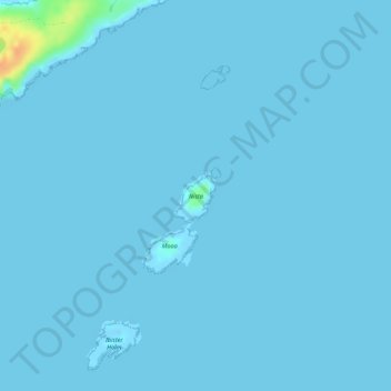
Nom : Carte topographique Nista, altitude, relief.
Lieu : Nista, Whalsay, Shetland, Scotland, United Kingdom (60.36639 -0.89923 60.36985 -0.89328)
Altitude moyenne : 1 m
Altitude minimum : -13 m
Altitude maximum : 34 m
Autres cartes topographiques
Cliquez sur une carte pour visualiser sa topographie, son altitude et son relief.
Island
United Kingdom > Scotland > Shetland > Mid Yell
Island, Yell, Mid Yell, Shetland, Scotland, United Kingdom
Altitude moyenne : 20 m
Sandness
United Kingdom > Scotland > Shetland
Sandness, Shetland, Scotland, ZE2 9PL, United Kingdom
Altitude moyenne : 48 m
Lerwick
United Kingdom > Scotland > Shetland
Lerwick, Shetland, Scotland, United Kingdom
Altitude moyenne : 34 m
Fair Isle
United Kingdom > Scotland > Shetland > Stonybreck
Fair Isle, Stonybreck, Shetland, Scotland, ZE2 9JU, United Kingdom
Altitude moyenne : 22 m
Shetland
United Kingdom > Scotland > Shetland
Shetland, Scotland, United Kingdom
Altitude moyenne : 11 m