
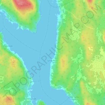
Carte topographique Sandy Point
Carte interactive
Cliquez sur la carte pour afficher l’altitude.
À propos de cette carte
Nom : Carte topographique Sandy Point, altitude, relief.
Altitude moyenne : 23 m
Altitude minimum : -1 m
Altitude maximum : 84 m
Autres cartes topographiques
Cliquez sur une carte pour visualiser sa topographie, son altitude et son relief.
Barrington Passage
Canada > Nova Scotia > Shelburne County > Barrington Passage
Barrington Passage, Municipality of the District of Barrington, Shelburne County, Nova Scotia, B0W 1E0, Canada
Altitude moyenne : 13 m
Rocky Creek
Canada > Nova Scotia > Shelburne County > Lower Clyde River
Rocky Creek, Lower Clyde River, Municipality of the District of Barrington, Shelburne County, Nova Scotia, B0W 1R0, Canada
Altitude moyenne : 48 m
West Head
Canada > Nova Scotia > Shelburne County
West Head, Municipality of the District of Barrington, Shelburne County, Nova Scotia, B0W 3B0, Canada
Altitude moyenne : 3 m
Blacksmiths Beach
Canada > Nova Scotia > Shelburne County > Cape Negro Island
Blacksmiths Beach, Cape Negro Island, Municipality of the District of Barrington, Shelburne County, Nova Scotia, B0W 1K0, Canada
Altitude moyenne : 2 m