
Faire un don
Équipez-vous pour votre prochaine aventure :
En tant que Partenaire Amazon, ce site perçoit une commission sur les achats éligibles sans surcoût pour vous.
Carte topographique Fredersdorf-Vogelsdorf
Cliquez sur la carte pour afficher l’altitude.
Faire un don
Équipez-vous pour votre prochaine aventure :
En tant que Partenaire Amazon, ce site perçoit une commission sur les achats éligibles sans surcoût pour vous.
Fredersdorf-Vogelsdorf
Gemeinden: Alt Tucheband | Beiersdorf-Freudenberg | Bleyen-Genschmar | Bliesdorf | Falkenberg | Falkenhagen (Mark) | Fichtenhöhe | Fredersdorf-Vogelsdorf | Garzau-Garzin | Golzow | Gusow-Platkow | Heckelberg-Brunow | Höhenland | Hoppegarten | Küstriner Vorland | Letschin | Lietzen | Lindendorf | Märkische Höhe | Neuenhagen bei Berlin | Neuhardenberg | Neulewin | Neutrebbin | Oberbarnim | Oderaue | Petershagen/Eggersdorf | Podelzig | Prötzel | Rehfelde | Reichenow-Möglin | Reitwein | Rüdersdorf bei Berlin | Treplin | Vierlinden | Waldsieversdorf | Zechin | Zeschdorf
Faire un don
Équipez-vous pour votre prochaine aventure :
En tant que Partenaire Amazon, ce site perçoit une commission sur les achats éligibles sans surcoût pour vous.
À propos de cette carte
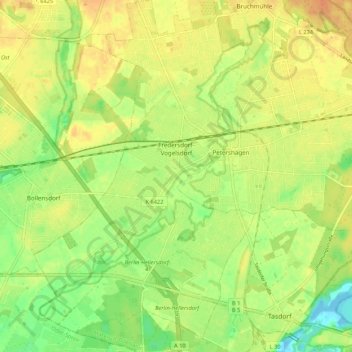
Nom : Carte topographique Fredersdorf-Vogelsdorf, altitude, relief.
Altitude moyenne : 54 m
Altitude minimum : 35 m
Altitude maximum : 67 m
Faire un don
Équipez-vous pour votre prochaine aventure :
En tant que Partenaire Amazon, ce site perçoit une commission sur les achats éligibles sans surcoût pour vous.
Autres cartes topographiques
Cliquez sur une carte pour visualiser sa topographie, son altitude et son relief.
Schlacht um die Seelower Höhen
Deutschland > Brandenburg > Märkisch-Oderland > Seelow
Die Schlacht um die Seelower Höhen vom 16. bis 19. April 1945 eröffnete die Schlacht um Berlin am Ende des Zweiten Weltkrieges. Seelow liegt etwa 70 km östlich von Berlin am Oderbruch, daher wird auch von der Schlacht an der Oder gesprochen. Knapp 1 Million Rotarmisten kämpften gegen etwa 190.000 deutsche…
Altitude moyenne : 22 m
Kerstenbruch
Deutschland > Brandenburg > Märkisch-Oderland > Neulewin > Neulewin
Altitude moyenne : 6 m
Faire un don
Équipez-vous pour votre prochaine aventure :
En tant que Partenaire Amazon, ce site perçoit une commission sur les achats éligibles sans surcoût pour vous.
Seeberg Dorf
Deutschland > Brandenburg > Märkisch-Oderland > Altlandsberg > Seeberg Dorf
Altitude moyenne : 60 m
Faire un don
Équipez-vous pour votre prochaine aventure :
En tant que Partenaire Amazon, ce site perçoit une commission sur les achats éligibles sans surcoût pour vous.
Buckowsee
Deutschland > Brandenburg > Märkisch-Oderland > Buckow
Auf der Höhe des mittleren Nordufers liegt die Reha-Klinik Waldfrieden für Mutter und Kind, ein markanter schlossähnlicher Gründerzeitbau mit eigenem Badestrand. Zuvor bereits von Adolf Orthey unter dem Namen Waldfrieden als Privat-Sanatorium betrieben, wurde das Haus 1918 von der Berliner Ortskrankenkasse…
Altitude moyenne : 44 m
Oderaue
Deutschland > Brandenburg > Märkisch-Oderland
Die Europabrücke Neurüdnitz–Siekierki gilt als längste Brücke über die Oder und wurde um 1920 gebaut. Der Viadukt besteht aus zwei hintereinanderstehenden Brücken von je 330 Metern Länge. Das Bauwerk war seit Mitte der 2010er Jahre wegen massiver Schäden gesperrt und wurde im Juni 2022 für…
Altitude moyenne : 42 m
Eggersdorf-Süd
Deutschland > Brandenburg > Märkisch-Oderland > Petershagen/Eggersdorf
Altitude moyenne : 57 m
Petershagen-Süd
Deutschland > Brandenburg > Märkisch-Oderland > Petershagen/Eggersdorf
Altitude moyenne : 54 m
Faire un don
Équipez-vous pour votre prochaine aventure :
En tant que Partenaire Amazon, ce site perçoit une commission sur les achats éligibles sans surcoût pour vous.
Beiersdorf
Deutschland > Brandenburg > Märkisch-Oderland > Beiersdorf-Freudenberg
Altitude moyenne : 89 m
Alt-Vogelsdorf
Deutschland > Brandenburg > Märkisch-Oderland > Fredersdorf-Vogelsdorf
Altitude moyenne : 51 m
Birkenstein
Deutschland > Brandenburg > Märkisch-Oderland > Hoppegarten > Dahlwitz-Hoppegarten
Altitude moyenne : 55 m
Faire un don
Équipez-vous pour votre prochaine aventure :
En tant que Partenaire Amazon, ce site perçoit une commission sur les achats éligibles sans surcoût pour vous.
Lichtenow Dorf
Deutschland > Brandenburg > Märkisch-Oderland > Rüdersdorf bei Berlin > Lichtenow
Altitude moyenne : 53 m
Schloss Wilkendorf
Deutschland > Brandenburg > Märkisch-Oderland > Altlandsberg > Gielsdorf > Wilkendorf
Altitude moyenne : 90 m
Faire un don
Équipez-vous pour votre prochaine aventure :
En tant que Partenaire Amazon, ce site perçoit une commission sur les achats éligibles sans surcoût pour vous.
Gusow
Deutschland > Brandenburg > Märkisch-Oderland
Der Ort liegt an der Alten Oder am Übergang der Seelower Höhen zum Oderbruch, zwei Kilometer südöstlich von Platkow und fünf Kilometer nordwestlich von Seelow. Die Nachbarorte sind Karlshof im Norden, Gusower Loose im Nordosten, Neulangsow im Osten, Werbiger Loose und Werbig im Südosten, Görlsdorf und…
Altitude moyenne : 19 m
Straussee
Deutschland > Brandenburg > Märkisch-Oderland > Strausberg > Strausberg
Altitude moyenne : 75 m
Faire un don
Équipez-vous pour votre prochaine aventure :
En tant que Partenaire Amazon, ce site perçoit une commission sur les achats éligibles sans surcoût pour vous.
Neue Mühle
Deutschland > Brandenburg > Märkisch-Oderland > Strausberg > Strausberg
Altitude moyenne : 55 m
Hortwinkel
Deutschland > Brandenburg > Märkisch-Oderland > Rüdersdorf bei Berlin > Rüdersdorf
Altitude moyenne : 59 m
Bergbrück
Deutschland > Brandenburg > Märkisch-Oderland > Rüdersdorf bei Berlin > Rüdersdorf
Altitude moyenne : 49 m
Faire un don
Équipez-vous pour votre prochaine aventure :
En tant que Partenaire Amazon, ce site perçoit une commission sur les achats éligibles sans surcoût pour vous.
Kleiner Tornowsee
Deutschland > Brandenburg > Märkisch-Oderland > Tornow
Das naturbelassene dystrophe Gewässer befindet sich nordöstlich von Buckow, dem Hauptort der Märkischen Schweiz, im Übergangsbereich des reliefstarken südöstlichen Barnimhangs zur Stobberniederung. Auf einer Höhe von 36,7 Metern ü. NN auf einer tertiären Scholle gelegen, folgt östlich in einer…
Altitude moyenne : 60 m
Naturpark Märkische Schweiz
Deutschland > Brandenburg > Märkisch-Oderland
Die Landschaft in der Märkischen Schweiz ist von der Eiszeit geprägt. Bei den Höhen handelt es sich um Endmoränen. Die höchste Erhebung des Naturparks ist mit 129 Meter der Krugberg. In der Nacheiszeit haben sich Schmelzwasserrinnen, Seen, Moore und Sölle gebildet. Im Zentrum des Naturparks liegt der…
Altitude moyenne : 63 m
Dolgelin
Deutschland > Brandenburg > Märkisch-Oderland > Lindendorf
Dolgelin ist eines der ältesten Höhendörfer am Westrand des Oderbruches. Grabungen seit dem Jahre 2000 brachten Besiedlungsspuren aus der Bronze- und Eisenzeit ans Tageslicht.
Altitude moyenne : 50 m
Müncheberg
Deutschland > Brandenburg > Märkisch-Oderland > Müncheberg > Müncheberg
Bei Müncheberg befand sich in den Zeiten des kalten Krieges der gemeinsame Gefechtsstand des funktechnischen Bataillons 61 und des Jagdgeschwaders 8 der NVA LSK/LV. Von 1978 bis 1981 wurde für rund 28 Millionen Mark der DDR ein zweietagiges monolithisches Schutzbauwerk höherer Schutzklasse errichtet, was…
Altitude moyenne : 69 m
Faire un don
Équipez-vous pour votre prochaine aventure :
En tant que Partenaire Amazon, ce site perçoit une commission sur les achats éligibles sans surcoût pour vous.
Sonnenburg
Deutschland > Brandenburg > Märkisch-Oderland > Bad Freienwalde (Oder) > Sonnenburg
Altitude moyenne : 84 m
Faire un don
Équipez-vous pour votre prochaine aventure :
En tant que Partenaire Amazon, ce site perçoit une commission sur les achats éligibles sans surcoût pour vous.
Letschin
Deutschland > Brandenburg > Märkisch-Oderland > Letschin > Letschin
Gemeinden: Alt Tucheband | Beiersdorf-Freudenberg | Bleyen-Genschmar | Bliesdorf | Falkenberg | Falkenhagen (Mark) | Fichtenhöhe | Fredersdorf-Vogelsdorf | Garzau-Garzin | Golzow | Gusow-Platkow | Heckelberg-Brunow | Höhenland | Hoppegarten | Küstriner Vorland | Letschin | Lietzen | Lindendorf | Märkische…
Altitude moyenne : 8 m
Friedenstal
Deutschland > Brandenburg > Märkisch-Oderland > Lindendorf > Friedenstal
Altitude moyenne : 23 m
Faire un don
Équipez-vous pour votre prochaine aventure :
En tant que Partenaire Amazon, ce site perçoit une commission sur les achats éligibles sans surcoût pour vous.