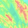
Carte topographique Sanitarium
Cliquez sur la carte pour afficher l’altitude.
À propos de cette carte

Nom : Carte topographique Sanitarium, altitude, relief.
Lieu : Sanitarium, Napa County, California, 94574, United States (38.52491 -122.49554 38.56491 -122.45554)
Altitude moyenne : 214 m
Altitude minimum : 68 m
Altitude maximum : 546 m
Autres cartes topographiques
Cliquez sur une carte pour visualiser sa topographie, son altitude et son relief.


Napa Valley AVA
United States > California > Napa County
Napa Valley's climate and geography are shaped by a unique cooling effect, crucial for premium grape growing. Originating from a cold ocean current from Alaska, this effect involves fog formation and cool air influx from the Pacific, offset by warmer air rising from California's Central Valley. This dynamic…
Altitude moyenne : 222 m



Napa Valley AVA
United States > California > Napa County
Napa Valley's climate and geography are shaped by a unique cooling effect, crucial for premium grape growing. Originating from a cold ocean current from Alaska, this effect involves fog formation and cool air influx from the Pacific, offset by warmer air rising from California's Central Valley. This dynamic…
Altitude moyenne : 222 m