
Carte topographique Wasagaming
Cliquez sur la carte pour afficher l’altitude.
Wasagaming
Wasagaming has a subarctic climate (Dfc) due to its northerly location and high elevation. Winters are extremely cold and relatively dry with little chance of a mid-winter thaw. The average annual temperature is 0.7 °C (33.3 °F). Annual precipitation is 488 mm (19.2 in).
À propos de cette carte
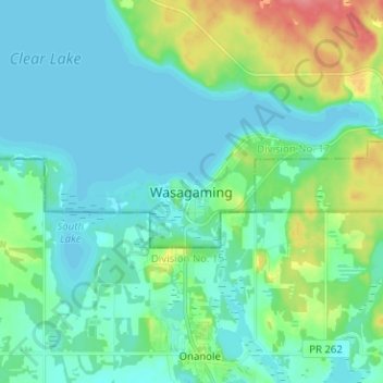
Nom : Carte topographique Wasagaming, altitude, relief.
Altitude moyenne : 630 m
Altitude minimum : 615 m
Altitude maximum : 683 m
Autres cartes topographiques
Cliquez sur une carte pour visualiser sa topographie, son altitude et son relief.
Riding Mountain National Park
Canada > Manitoba > Unorganized Division No. 17 > Wasagaming
Riding Mountain Biosphere Reserve covers 15,000 square kilometers of land in South-western Manitoba, with the core area, Riding Mountain National Park (RMNP), covering nearly 3,000 square kilometers. It is some 300 km northwest of Winnipeg, Manitoba. The local climate is cool and moist due to a higher…
Altitude moyenne : 488 m