
Carte topographique Rosetown
Carte interactive
Cliquez sur la carte pour afficher l’altitude.
À propos de cette carte
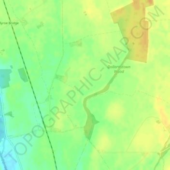
Nom : Carte topographique Rosetown, altitude, relief.
Altitude moyenne : 66 m
Altitude minimum : 50 m
Altitude maximum : 78 m
Autres cartes topographiques
Cliquez sur une carte pour visualiser sa topographie, son altitude et son relief.
Kildoon
Kildoon, The Municipal District of Athy, County Kildare, Leinster, Ireland
Altitude moyenne : 74 m
The Municipal District of Clane — Maynooth
The Municipal District of Clane — Maynooth, County Kildare, Leinster, Ireland
Altitude moyenne : 86 m
The Municipal District of Naas
The Municipal District of Naas, County Kildare, Leinster, Ireland
Altitude moyenne : 152 m