
Faire un don
Équipez-vous pour votre prochaine aventure :
En tant que Partenaire Amazon, ce site perçoit une commission sur les achats éligibles sans surcoût pour vous.
Carte topographique Putanges-Pont-Écrepin
Cliquez sur la carte pour afficher l’altitude.
Faire un don
Équipez-vous pour votre prochaine aventure :
En tant que Partenaire Amazon, ce site perçoit une commission sur les achats éligibles sans surcoût pour vous.
Putanges-Pont-Écrepin
Cependant, il faut prendre put au sens non pas de « sale », mais plutôt de « mauvais » (signification que sale peut aussi avoir). Deux anciens lieux-dits de Lisieux portent le nom de Putangle (de Puto angulo 1200, Putangle 1267) et Bonangle (Bone Angle 1293, Bon Angle 1326), ce dernier devenu aujourd'hui la rue Bon Ange. Il s'agit de deux coins de l'ancienne île Saint-Dominique sur la Touques, le put angle « mauvais coin » est formé par le coude dangereux ou malcommode de la rivière, et le bon angle « bon coin » s'oppose ainsi à lui. La topographie à Putanges est identique puisqu'il est situé sur une courbe prononcée de l'Orne.
Faire un don
Équipez-vous pour votre prochaine aventure :
En tant que Partenaire Amazon, ce site perçoit une commission sur les achats éligibles sans surcoût pour vous.
À propos de cette carte
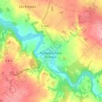
Nom : Carte topographique Putanges-Pont-Écrepin, altitude, relief.
Altitude moyenne : 186 m
Altitude minimum : 119 m
Altitude maximum : 248 m
Faire un don
Équipez-vous pour votre prochaine aventure :
En tant que Partenaire Amazon, ce site perçoit une commission sur les achats éligibles sans surcoût pour vous.
Autres cartes topographiques
Cliquez sur une carte pour visualiser sa topographie, son altitude et son relief.
Lac de Rabodanges
France > Normandie > Orne > Putanges-le-Lac > Sainte-Croix-sur-Orne
Altitude moyenne : 176 m
Le Châtelier
France > Normandie > Orne > Putanges-le-Lac > Putanges-Pont-Écrepin
Altitude moyenne : 186 m
Le Buisson
France > Normandie > Orne > Putanges-le-Lac > Putanges-Pont-Écrepin
Altitude moyenne : 191 m
Faire un don
Équipez-vous pour votre prochaine aventure :
En tant que Partenaire Amazon, ce site perçoit une commission sur les achats éligibles sans surcoût pour vous.
Le Hamel
France > Normandie > Orne > Putanges-le-Lac > La Forêt-Auvray > Le Hamel
Altitude moyenne : 173 m
Les Courtils
France > Normandie > Orne > Putanges-le-Lac > Putanges-Pont-Écrepin
Altitude moyenne : 186 m
Lac de Rabodanges
France > Normandie > Orne > Putanges-le-Lac > Sainte-Croix-sur-Orne
Altitude moyenne : 176 m
Faire un don
Équipez-vous pour votre prochaine aventure :
En tant que Partenaire Amazon, ce site perçoit une commission sur les achats éligibles sans surcoût pour vous.