
Carte topographique Valenzuela
Carte interactive
Cliquez sur la carte pour afficher l’altitude.
À propos de cette carte
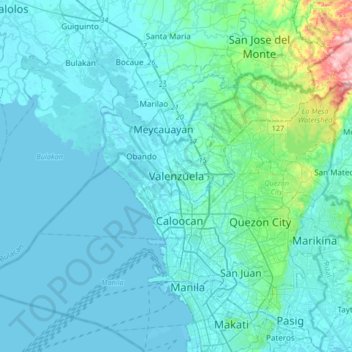
Nom : Carte topographique Valenzuela, altitude, relief.
Lieu : Valenzuela, Third District, Metro Manila, 1441, Philippines (14.53169 120.80945 14.85169 121.12945)
Altitude moyenne : 24 m
Altitude minimum : -3 m
Altitude maximum : 258 m
The highest elevation point is 38 metres (125 ft) above sea level. Having a surface gradient of 0.55% and a gentle slope, hilly landscape is located in the industrial section of the city in Canumay. The average elevation point is 2 metres (6.6 ft) above sea level.
Autres cartes topographiques
Cliquez sur une carte pour visualiser sa topographie, son altitude et son relief.
Malinta
Malinta, 1st District, Valenzuela, Northern Manila District, Metro Manila, Philippines
Altitude moyenne : 8 m
Punturin
Punturin, Valenzuela, Metro Manila, 1447, Philippines
Altitude moyenne : 16 m
Malanday
Malanday, 1st District, Valenzuela, Northern Manila District, Metro Manila, 1444, Philippines
Altitude moyenne : 4 m