
Carte topographique Dobel
Carte interactive
Cliquez sur la carte pour afficher l’altitude.
À propos de cette carte
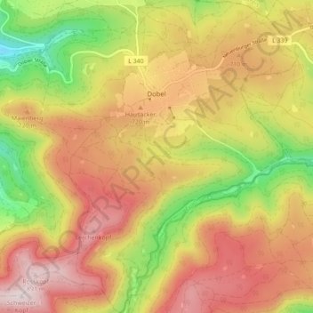
Nom : Carte topographique Dobel, altitude, relief.
Altitude moyenne : 658 m
Altitude minimum : 366 m
Altitude maximum : 901 m
The municipality (Gemeinde) of Dobel is located situated in the district of Calw, in the German state of Baden-Württemberg. Dobel lies at the northwest corner of the district, bordering the districts of Rastatt and the Enz. The municipal area is physically located in the Grinde area of the Black Forest, on a plateau between the valleys of the Enz and Alb rivers. Elevation above sea level in the municipal area ranges from a high of 882 meters (2,894 ft) Normalnull (NN) at the top of the Rosskopf to a low of 405 meters (1,329 ft) NN.
Autres cartes topographiques
Cliquez sur une carte pour visualiser sa topographie, son altitude et son relief.
Unterreichenbach
Germany > Baden-Württemberg > Landkreis Calw
Unterreichenbach, Verwaltungsgemeinschaft Bad Liebenzell, Landkreis Calw, Baden-Württemberg, Germany
Altitude moyenne : 493 m
Zieflensberg
Germany > Baden-Württemberg > Landkreis Calw > Bad Herrenalb > Zieflensberg
Zieflensberg, Herrenalb, Bad Herrenalb, Verwaltungsgemeinschaft Bad Herrenalb, Landkreis Calw, Baden-Württemberg, 76332, Germany
Altitude moyenne : 668 m
Wildbad
Germany > Baden-Württemberg > Landkreis Calw > Bad Wildbad
Wildbad, Bad Wildbad, Verwaltungsgemeinschaft Bad Wildbad, Landkreis Calw, Baden-Württemberg, 75323, Germany
Altitude moyenne : 694 m
Lichtenbach
Germany > Baden-Württemberg > Landkreis Calw > Haiterbach
Lichtenbach, Beihingen, Haiterbach, Verwaltungsgemeinschaft Nagold, Landkreis Calw, Baden-Württemberg, 72221, Germany
Altitude moyenne : 541 m
Bad Wildbad
Germany > Baden-Württemberg > Landkreis Calw
Bad Wildbad, Verwaltungsgemeinschaft Bad Wildbad, Landkreis Calw, Baden-Württemberg, 75323, Germany
Altitude moyenne : 688 m