
Carte topographique Quy Nhơn
Carte interactive
Cliquez sur la carte pour afficher l’altitude.
À propos de cette carte
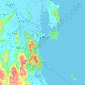
Nom : Carte topographique Quy Nhơn, altitude, relief.
Lieu : Quy Nhơn, Bình Định Province, Vietnam (13.60518 109.08911 13.90424 109.36331)
Altitude moyenne : 62 m
Altitude minimum : -3 m
Altitude maximum : 781 m
Quy Nhon has a varied topography, being extremely diversified with mountains and forests, hills, fields, salt marshes, plains, lagoons, lakes, rivers, shorelines, peninsulas and islands. Its coastline is 42 kilometres or 26 miles long with sandy beaches, abundant seafood resources and other natural products of economic value. Hà Thanh River flows through city.
Autres cartes topographiques
Cliquez sur une carte pour visualiser sa topographie, son altitude et son relief.
Phường Trần Quang Diệu
Vietnam > Bình Định Province > Quy Nhơn
Phường Trần Quang Diệu, Quy Nhơn, Bình Định Province, Vietnam
Altitude moyenne : 45 m
Định Quang
Vietnam > Bình Định Province > Vĩnh Thạnh District
Định Quang, Vĩnh Thạnh District, Bình Định Province, Vietnam
Altitude moyenne : 70 m
Phu My
Vietnam > Bình Định Province > Phù Mỹ District
Phu My, Phù Mỹ District, Bình Định Province, Vietnam
Altitude moyenne : 36 m
Phù Mỹ District
Phù Mỹ District, Bình Định Province, Vietnam
Altitude moyenne : 63 m