
Carte topographique Trevi
Carte interactive
Cliquez sur la carte pour afficher l’altitude.
Trevi
The natural environment of the territory as a whole remains largely unspoiled, this despite being significantly populated for millennia. The mountainous area is now witnessing a considerable depopulation — as elsewhere in Italy, in the second half of the 20th century settlements at the highest elevations have been rapidly losing their inhabitants to the plains. The most important growth areas since the period following World War II have been Borgo Trevi (commercial, residential, and offices), Pietrarossa (industrial), and Matigge (light and medium industry, commercial).
À propos de cette carte
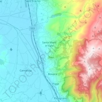
Nom : Carte topographique Trevi, altitude, relief.
Lieu : Trevi, Perugia, Umbria, 06039, Italy (42.83403 12.69013 42.93376 12.82816)
Altitude moyenne : 507 m
Altitude minimum : 200 m
Altitude maximum : 1 418 m
Autres cartes topographiques
Cliquez sur une carte pour visualiser sa topographie, son altitude et son relief.
Ponticelli
Ponticelli is a frazione of the comune of Città della Pieve in the Province of Perugia, Umbria, central Italy. It stands at an elevation of 249 metres above sea level. At the time of the Istat census of 2001 it had 610 inhabitants.
Altitude moyenne : 275 m