
Carte topographique Pankop
Carte interactive
Cliquez sur la carte pour afficher l’altitude.
À propos de cette carte
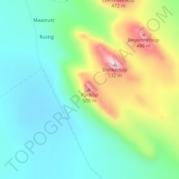
Nom : Carte topographique Pankop, altitude, relief.
Altitude moyenne : 260 m
Altitude minimum : 142 m
Altitude maximum : 521 m
Autres cartes topographiques
Cliquez sur une carte pour visualiser sa topographie, son altitude et son relief.
Algeria
South Africa > Western Cape > West Coast District Municipality > Cederberg Local Municipality
Algeria, Cederberg Local Municipality, West Coast District Municipality, Western Cape, South Africa
Altitude moyenne : 781 m
Elandsbaai
South Africa > Western Cape > West Coast District Municipality > Cederberg Local Municipality
Elandsbaai, Cederberg Local Municipality, West Coast District Municipality, Western Cape, 8101, South Africa
Altitude moyenne : 43 m
Citrusdal
South Africa > Western Cape > West Coast District Municipality > Cederberg Local Municipality
Citrusdal, Cederberg Local Municipality, West Coast District Municipality, Western Cape, 7340, South Africa
Altitude moyenne : 256 m
Clanwilliam
South Africa > Western Cape > West Coast District Municipality > Cederberg Local Municipality
Clanwilliam, Cederberg Local Municipality, West Coast District Municipality, Western Cape, 8135, South Africa
Altitude moyenne : 162 m
Bulshoek Dam
South Africa > Western Cape > West Coast District Municipality > Cederberg Local Municipality
Bulshoek Dam, Cederberg Ward 6, Cederberg Local Municipality, West Coast District Municipality, Western Cape, South Africa
Altitude moyenne : 184 m
Cederberg
South Africa > Western Cape > West Coast District Municipality > Cederberg Local Municipality
Cederberg, Cederberg Local Municipality, West Coast District Municipality, Western Cape, South Africa
Altitude moyenne : 997 m
Wolfberg
South Africa > Western Cape > West Coast District Municipality > Cederberg Local Municipality
Wolfberg, Cederberg Local Municipality, West Coast District Municipality, Western Cape, South Africa
Altitude moyenne : 1 399 m
Cederberg Ward 1
South Africa > Western Cape > West Coast District Municipality > Cederberg Local Municipality
Cederberg Ward 1, Cederberg Local Municipality, West Coast District Municipality, Western Cape, South Africa
Altitude moyenne : 690 m
Wupperthal
South Africa > Western Cape > West Coast District Municipality > Cederberg Local Municipality
Wupperthal, Cederberg Local Municipality, West Coast District Municipality, Western Cape, South Africa
Altitude moyenne : 636 m
Wolfberg Arch
South Africa > Western Cape > West Coast District Municipality > Cederberg Local Municipality > Cederberg
Wolfberg Arch, Die Trap, Cederberg Ward 1, Cederberg, Cederberg Local Municipality, West Coast District Municipality, Western Cape, South Africa
Altitude moyenne : 1 413 m