
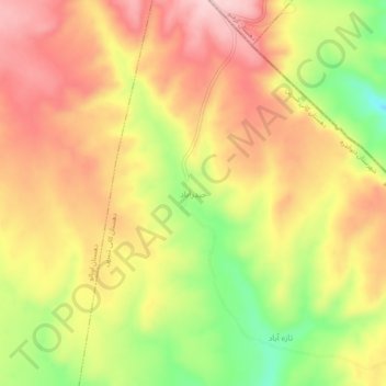
Carte topographique Heydarabad
Carte interactive
Cliquez sur la carte pour afficher l’altitude.
À propos de cette carte
Nom : Carte topographique Heydarabad, altitude, relief.
Altitude moyenne : 2 323 m
Altitude minimum : 2 193 m
Altitude maximum : 2 418 m
Autres cartes topographiques
Cliquez sur une carte pour visualiser sa topographie, son altitude et son relief.
`Azizabad
Iran > Kurdistan Province > Divandarreh County > دهستان چهل چشمه
`Azizabad, دهستان چهل چشمه, بخش مرکزی, Divandarreh County, Kurdistan Province, Iran
Altitude moyenne : 1 875 m
Kalkan
Iran > Kurdistan Province > Divandarreh County
Kalkan, بخش کرفتو, Divandarreh County, Kurdistan Province, Iran
Altitude moyenne : 2 111 m
Zardak
Iran > Kurdistan Province > Divandarreh County
Zardak, Pakhsh Sarul, Divandarreh County, Kurdistan Province, Iran
Altitude moyenne : 2 246 m
Kapak
Iran > Kurdistan Province > Divandarreh County > دهستان سارال > Kapak
Kapak, دهستان سارال, Pakhsh Sarul, Divandarreh County, Kurdistan Province, Iran
Altitude moyenne : 2 122 m
Kasnazan
Iran > Kurdistan Province > Divandarreh County
Kasnazan, بخش کرفتو, Divandarreh County, Kurdistan Province, Iran
Altitude moyenne : 2 076 m