
Carte topographique Pedra Azul
Carte interactive
Cliquez sur la carte pour afficher l’altitude.
Pedra Azul
The city belongs to the mesoregion of Jequitinhonha and to the microregion of Pedra Azul. The elevation of the municipal seat is 617 meters. It became a municipality in 1911. This municipality is located 16 km. to the east of the important BR-116 highway, which links Rio de Janeiro to Salvador. The boundary with the state of Bahia is 49 km. to the northeast.
À propos de cette carte
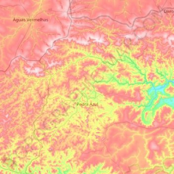
Nom : Carte topographique Pedra Azul, altitude, relief.
Altitude moyenne : 773 m
Altitude minimum : 418 m
Altitude maximum : 1 068 m