
Carte topographique Balikpapan
Carte interactive
Cliquez sur la carte pour afficher l’altitude.
Balikpapan
Topography of Balikpapan is generally hilly (85%), with only small areas of flat land (15%), mostly along the coast and surrounding the hilly areas. The hills are less than 100 meters (330 feet) higher than the adjacent valleys. The altitude of Balikpapan ranges from 0 to 80 meters (260 feet) above sea level. The city proper itself is located on eastern side of Bay of Balikpapan.
À propos de cette carte
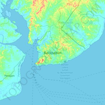
Nom : Carte topographique Balikpapan, altitude, relief.
Lieu : Balikpapan, East Kalimantan, 76128, Indonesia (-1.39987 116.69934 -1.07987 117.01934)
Altitude moyenne : 10 m
Altitude minimum : -4 m
Altitude maximum : 102 m