Géolocaliser

Carte topographique Woodgate

Cliquez sur la carte pour afficher l’altitude.

À propos de cette carte

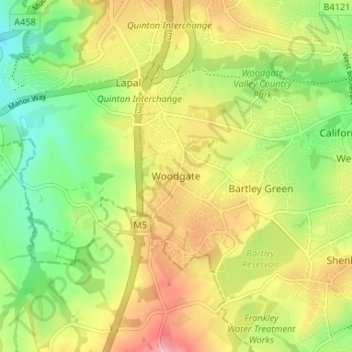
Nom : Carte topographique Woodgate, altitude, relief.

Lieu : Woodgate, Birmingham, West Midlands, England, B32 4LR, United Kingdom (52.41735 -2.03076 52.45735 -1.99076)

Altitude moyenne : 176 m

Altitude minimum : 114 m

Altitude maximum : 248 m

Autres cartes topographiques

Cliquez sur une carte pour visualiser sa topographie, son altitude et son relief.

Sutton Park

United Kingdom > England > Birmingham > Four Oaks

Altitude moyenne : 145 m

Edgbaston Reservoir

United Kingdom > England > Birmingham

Altitude moyenne : 155 m

Sutton Coldfield

United Kingdom > England > Birmingham

Altitude moyenne : 124 m

Lifford Reservoir

United Kingdom > England > Birmingham > Lifford

Altitude moyenne : 150 m

Pype Hayes

United Kingdom > England > Birmingham > Tyburn

Altitude moyenne : 104 m

Duddeston Viaduct

United Kingdom > England > Birmingham > Highgate

Altitude moyenne : 117 m

Frankley Reservoir

United Kingdom > England > Birmingham > Frankley

Altitude moyenne : 196 m

North Edgbaston

United Kingdom > England > Birmingham

Altitude moyenne : 162 m

Fox Covert

United Kingdom > England > Birmingham > Sutton Coldfield

Altitude moyenne : 108 m

Joy's Wood

United Kingdom > England > Birmingham > Wake Green

Altitude moyenne : 140 m

Perrott's Folly

United Kingdom > England > Birmingham > Chad Valley

Altitude moyenne : 153 m

Highbury Park

United Kingdom > England > Birmingham > Kings Heath

Altitude moyenne : 142 m

Sutton Coldfield

United Kingdom > England > Birmingham

Altitude moyenne : 124 m

Sutton Park

United Kingdom > England > Birmingham > Four Oaks

Altitude moyenne : 145 m

Équipez-vous pour votre prochaine aventure :

📍GPS de randonnée - GPS portables pour suivre itinéraires et altitudes
🔦Lanterne de camping LED - Éclairage d'ambiance pour l'intérieur de la tente
🎒Housse de pluie pour sac à dos - Protection supplémentaire pour garder votre contenu au sec
Tentes de camping - Tentes adaptées à la randonnée et au bivouac
🧤Gants chauffants rechargeables - Le confort ultime pour la cartographie hivernale

En tant que Partenaire Amazon, ce site perçoit une commission sur les achats éligibles sans surcoût pour vous.