
Carte topographique บ้านหนองยาว
Carte interactive
Cliquez sur la carte pour afficher l’altitude.
À propos de cette carte
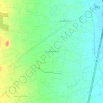
Nom : Carte topographique บ้านหนองยาว, altitude, relief.
Lieu : บ้านหนองยาว, นายาง, Phetchaburi, Thailand (12.77384 99.90169 12.81384 99.94169)
Altitude moyenne : 31 m
Altitude minimum : 11 m
Altitude maximum : 73 m
Autres cartes topographiques
Cliquez sur une carte pour visualiser sa topographie, son altitude et son relief.
หาดชะอำ
Thailand > Phetchaburi > สามพระยา > ชะอำ
หาดชะอำ, ชะอำ, นายาง, สามพระยา, Phetchaburi, Thailand
Altitude moyenne : 3 m