
Carte topographique Chatsworth
Carte interactive
Cliquez sur la carte pour afficher l’altitude.
À propos de cette carte
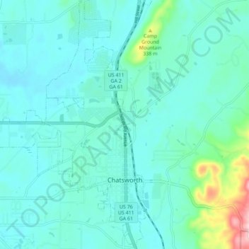
Nom : Carte topographique Chatsworth, altitude, relief.
Lieu : Chatsworth, Murray County, Georgia, United States (34.74681 -84.82888 34.81781 -84.76255)
Altitude moyenne : 241 m
Altitude minimum : 203 m
Altitude maximum : 460 m
Chatsworth is located in central Murray County at 34°46′20″N 84°46′44″W / 34.77222°N 84.77889°W / 34.77222; -84.77889 (34.772336, -84.778977), in northwestern Georgia. It sits at an elevation of 750 feet (230 m) on the west side of the valley of Holly Creek, with 2,840-foot (870 m) Fort Mountain and 2,780-foot (850 m) Cohutta Mountain rising over the valley to the east.
Autres cartes topographiques
Cliquez sur une carte pour visualiser sa topographie, son altitude et son relief.
Cisco
United States > Georgia > Murray County
Cisco, Murray County, Georgia, 30708, United States
Altitude moyenne : 293 m