
Carte topographique Province of Carhuaz
Carte interactive
Cliquez sur la carte pour afficher l’altitude.
À propos de cette carte
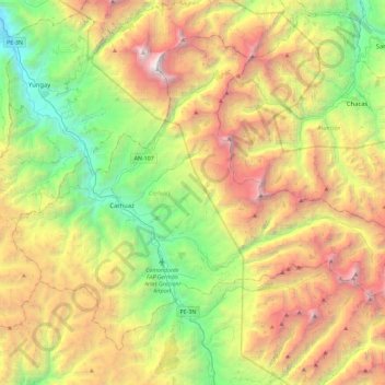
Nom : Carte topographique Province of Carhuaz, altitude, relief.
Lieu : Province of Carhuaz, Ancash, Peru (-9.45280 -77.77670 -9.08191 -77.31813)
Altitude moyenne : 4 038 m
Altitude minimum : 2 248 m
Altitude maximum : 6 726 m
The Cordillera Blanca traverses the province. Waskaran, its highest elevation, lies on the border to the Yungay Province. Pallqarahu, Pukaranra, Qupa, Tuqllarahu, Wallqan and Yanarahu belong to the highest peaks of the province. Other mountains are listed below:[2]
Autres cartes topographiques
Cliquez sur une carte pour visualiser sa topographie, son altitude et son relief.
Vallunareju Norte
Vallunareju Norte, Tarica, Province of Huaraz, Ancash, Peru
Altitude moyenne : 5 177 m
San Juan Mountain
San Juan Mountain, Avenida Circunvalacion Nte, Caraz, Province of Huaylas, Ancash, 02165, Peru
Altitude moyenne : 2 438 m
Collahuasi
Collahuasi, Recuay, Province of Recuay, Ancash, Peru
Altitude moyenne : 3 623 m
Tortugas
Peru > Ancash > Comandante Noel
Tortugas, Comandante Noel, Province of Casma, Ancash, Peru
Altitude moyenne : 70 m
Laguna Radian
Peru > Ancash > Independencia
Laguna Radian, Independencia, Province of Huaraz, Ancash, Peru
Altitude moyenne : 3 913 m
Carhuayoc
Peru > Ancash > San Marcos
Carhuayoc, San Marcos, Province of Huari, Ancash, Peru
Altitude moyenne : 3 518 m
Chavin Archaeological Site
Peru > Ancash > Chavín de Huantar > Chavin de Huantar > Cochas
Chavin Archaeological Site, Cochas, Chavin de Huantar, Chavín de Huantar, Province of Huari, Ancash, Peru
Altitude moyenne : 3 407 m
Nuevo Chimbote
Peru > Ancash > Nuevo Chimbote
Nuevo Chimbote, Santa, Ancash, 02710, Peru
Altitude moyenne : 34 m
Callo
Peru > Ancash > San Pedro de Chaná > Santa Rita > Callo
Callo, Santa Rita, San Pedro de Chaná, Province of Huari, Ancash, Peru
Altitude moyenne : 3 451 m
Laguna Purhuay
Laguna Purhuay, Huari, Province of Huari, Ancash, Peru
Altitude moyenne : 3 777 m
Laguna Palococha
Laguna Palococha, AN-110, Ticapampa, Province of Recuay, Ancash, Peru
Altitude moyenne : 3 765 m
Province of Recuay
Province of Recuay, Cátac, Recuay, Ancash, Peru
Altitude moyenne : 4 232 m
Province of Carhuaz
Province of Carhuaz, Marcará, Carhuaz, Ancash, Peru
Altitude moyenne : 3 217 m
Alpamayo
Peru > Ancash > Santa Cruz
Alpamayo, Santa Cruz, Huaylas, Ancash, Peru
Altitude moyenne : 5 210 m