
Carte topographique Qiaoxi District
Carte interactive
Cliquez sur la carte pour afficher l’altitude.
À propos de cette carte
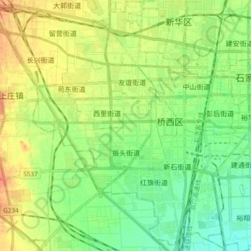
Nom : Carte topographique Qiaoxi District, altitude, relief.
Lieu : Qiaoxi District, Shijiazhuang City, Hebei, China (37.97151 114.37066 38.07266 114.50621)
Altitude moyenne : 80 m
Altitude minimum : 64 m
Altitude maximum : 99 m
Autres cartes topographiques
Cliquez sur une carte pour visualiser sa topographie, son altitude et son relief.
Lingshou County
China > Hebei > Shijiazhuang City
Lingshou County, Shijiazhuang City, Hebei, China
Altitude moyenne : 319 m
Pingshan County
China > Hebei > Shijiazhuang City
Pingshan County, Shijiazhuang City, Hebei, China
Altitude moyenne : 682 m
Wancheng
China > Hebei > Shijiazhuang City
Wancheng, Gaoyi County, Shijiazhuang City, Hebei, China
Altitude moyenne : 65 m
Shijiazhuang City
China > Hebei > Shijiazhuang City
Jiazhuang, Jingxing Mining District, Shijiazhuang City, Hebei, China
Altitude moyenne : 365 m