
Carte topographique French Guiana
Carte interactive
Cliquez sur la carte pour afficher l’altitude.
À propos de cette carte
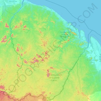
Nom : Carte topographique French Guiana, altitude, relief.
Lieu : French Guiana, France (2.11094 -54.60269 5.74812 -51.63461)
Altitude moyenne : 104 m
Altitude minimum : -2 m
Altitude maximum : 791 m
French Guiana has a tropical rainforest climate. Located within six degrees of the Equator and rising only to modest elevations, French Guiana is hot and oppressively humid all year round. During most of the year, rainfall across the country is heavy due to the presence of the Intertropical Convergence Zone and its powerful thunderstorm cells. In most parts of French Guiana, rainfall is always especially heavy from December to June or July – typically over 330 millimetres or 13 inches can be expected each month during this period throughout the department. Between August and November, the eastern half experiences a "dry" season with as little as 30 millimetres or 1.18 inches in September and October, causing eastern French Guiana to be classed as a tropical monsoon climate (Köppen Am); Saint-Laurent-du-Maroni in the west has a tropical rainforest climate (Af).
Autres cartes topographiques
Cliquez sur une carte pour visualiser sa topographie, son altitude et son relief.
ile aux Sept Chapelets
France > French Guiana > Régina
ile aux Sept Chapelets, Régina, Saint-Georges, French Guiana, France
Altitude moyenne : 7 m
Saint-Laurent-du-Maroni
Saint-Laurent-du-Maroni, French Guiana, 97320, France
Altitude moyenne : 83 m
Mont Cépérou
France > French Guiana > Cayenne
Mont Cépérou, Cayenne, French Guiana, 97300, France
Altitude moyenne : 2 m
Mont Édouard
France > French Guiana > Saül
Mont Édouard, Saül, Saint-Laurent-du-Maroni, French Guiana, 97314, France
Altitude moyenne : 204 m
Kourou
France > French Guiana > Kourou
Kourou, Cayenne, French Guiana, 97310, France
Altitude moyenne : 35 m
Mont Maunoir
France > French Guiana > Camopi
Mont Maunoir, Camopi, Cayenne, French Guiana, 97330, France
Altitude moyenne : 136 m