Carte topographique Aluva
Cliquez sur la carte pour afficher l’altitude.
Aluva
Aluva Railway Station is a major stop for trains that passes north to south of Kerala. It is the third busiest station in Kochi city, after Ernakulam Junction railway station and Ernakulam Town railway station. The station is important for southern railway because of the number of passengers itself. The commuters and travellers from Idukki district have to use either this station or the Tripunithura railway station for all their train journeys as there is no possible railway in the Idukki topography. There are no trains starting or ending at this station, but there are a lot of trains which stop for considerable duration here.
À propos de cette carte
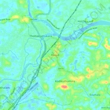
Nom : Carte topographique Aluva, altitude, relief.
Lieu : Aluva, Ernakulam, Kerala, 683101, India (10.06777 76.31685 10.14777 76.39685)
Altitude moyenne : 11 m
Altitude minimum : -2 m
Altitude maximum : 52 m
Autres cartes topographiques
Cliquez sur une carte pour visualiser sa topographie, son altitude et son relief.