
Carte topographique Wallula
Carte interactive
Cliquez sur la carte pour afficher l’altitude.
À propos de cette carte
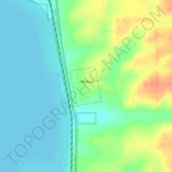
Nom : Carte topographique Wallula, altitude, relief.
Lieu : Wallula, Walla Walla County, Washington, United States (46.08161 -118.90909 46.08779 -118.90208)
Altitude moyenne : 119 m
Altitude minimum : 102 m
Altitude maximum : 151 m
Autres cartes topographiques
Cliquez sur une carte pour visualiser sa topographie, son altitude et son relief.
Touchet
United States > Washington > Walla Walla County > Touchet
Touchet, Walla Walla County, Washington, 99360, United States
Altitude moyenne : 139 m
Port Kelley
United States > Washington > Walla Walla County
Port Kelley, Walla Walla County, Washington, United States
Altitude moyenne : 255 m
Whitman Mission National Historic Site
United States > Washington > Walla Walla County
Whitman Mission National Historic Site, Walla Walla County, Washington, United States
Altitude moyenne : 196 m
Walla Walla
United States > Washington > Walla Walla County > Walla Walla
Walla Walla, Walla Walla County, Washington, United States
Altitude moyenne : 297 m