
Carte topographique Bulverde
Carte interactive
Cliquez sur la carte pour afficher l’altitude.
À propos de cette carte
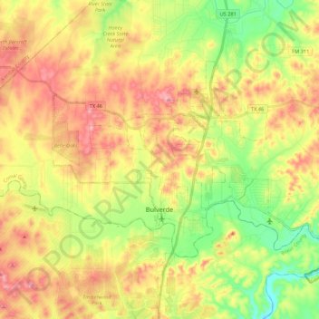
Nom : Carte topographique Bulverde, altitude, relief.
Lieu : Bulverde, Comal County, Texas, United States (29.71563 -98.52530 29.83061 -98.31001)
Altitude moyenne : 364 m
Altitude minimum : 267 m
Altitude maximum : 468 m
Autres cartes topographiques
Cliquez sur une carte pour visualiser sa topographie, son altitude et son relief.
Comal River
United States > Texas > Comal County > New Braunfels > Landa Park Estates
Comal River, Landa Park Estates, New Braunfels, Comal County, Texas, 78130, United States
Altitude moyenne : 206 m
Canyon Springs
United States > Texas > Comal County
Canyon Springs, Comal County, Texas, 79133, United States
Altitude moyenne : 310 m
New Braunfels
United States > Texas > Comal County
New Braunfels, Comal County, Texas, United States
Altitude moyenne : 228 m
Spring Branch
United States > Texas > Comal County
Spring Branch, Comal County, Texas, United States
Altitude moyenne : 347 m
Canyon Lake
United States > Texas > Comal County
Canyon Lake, Comal County, Texas, 78133, United States
Altitude moyenne : 296 m